IMAGES TAKEN NEAR TO
St. Lukes Road, BOURNEMOUTH, BH3 7LS
Introduction
This page details the photographs taken nearby to St. Lukes Road, BH3 7LS by members of the Geograph project.
The Geograph project started in 2005 with the aim of publishing, organising and preserving representative images for every square kilometre of Great Britain, Ireland and the Isle of Man.

There are currently over 7.5m images from over14,400 individuals and you can help contribute to the project by visiting https://www.geograph.org.uk
Image Map
Images are licensed for reuse under creativecommons.org/licenses/by-sa/2.0
Notes
- Clicking on the map will re-center to the selected point.
- The higher the marker number, the further away the image location is from the centre of the postcode.
Image Listing (94 Images Found)
Images are licensed for reuse under creativecommons.org/licenses/by-sa/2.0
Image
Details
Distance
1
Bournemouth : Alma Road
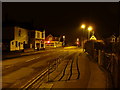
Alma Road is looking rather quieter than it does at other times of the day.
Image: © Lewis Clarke
Taken: 19 Feb 2010
0.05 miles

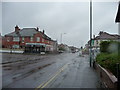
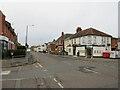
3
Bournemouth : Winton - Heron Court Road & St Luke's Road Junction
Image: © Lewis Clarke
Taken: 20 May 2009
0.07 miles
6

Bournemouth : Heron Court Road & St Luke's Road
Image: © Lewis Clarke
Taken: 20 May 2009
0.08 miles
7
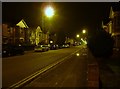
Bournemouth : Heron Court Road & Alma Road
Taken close to the road junction between the two roads at 2.30am when there was nothing but taxis ferrying drunken students, and a milk float about.
Image: © Lewis Clarke
Taken: 19 Feb 2010
0.09 miles
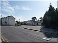
8
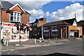
Junction of Alma Road and Heron Court Road
Corner shop and Methodist Church either side of Heron Court Road. The church can be seen more clearly in Image
Image: © David Martin
Taken: 3 Mar 2024
0.09 miles
9
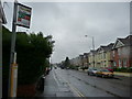
Alma Road, Winton, Bournemouth
Alma Road, through the suburb of Winton in Bournemouth, forms part of the route of the A3049.
Image: © Malc McDonald
Taken: 7 Feb 2022
0.09 miles
10
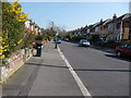
Bournemouth : Winton, Fitzharris Avenue
Fitzharris Avenue has some dangerous trees - I was walking along the road in the dark once whilst looking down sending a text and walking into one - nearly had my eye out.
Image: © Lewis Clarke
Taken: 20 Mar 2009
0.09 miles