IMAGES TAKEN NEAR TO
Glenferness Avenue, BOURNEMOUTH, BH3 7EY
Introduction
This page details the photographs taken nearby to Glenferness Avenue, BH3 7EY by members of the Geograph project.
The Geograph project started in 2005 with the aim of publishing, organising and preserving representative images for every square kilometre of Great Britain, Ireland and the Isle of Man.

There are currently over 7.5m images from over14,400 individuals and you can help contribute to the project by visiting https://www.geograph.org.uk
Image Map
Images are licensed for reuse under creativecommons.org/licenses/by-sa/2.0
Notes
- Clicking on the map will re-center to the selected point.
- The higher the marker number, the further away the image location is from the centre of the postcode.
Image Listing (21 Images Found)
Images are licensed for reuse under creativecommons.org/licenses/by-sa/2.0
Image
Details
Distance
1
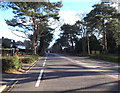
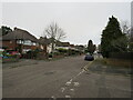
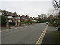
Glenferness Avenue
Affluent tree-lined suburbia in Bournemouth. Glenferness Avenue near its junction with Cawdor Road.
Image: © Peter Kazmierczak
Taken: 7 Mar 2016
0.03 miles
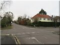
2
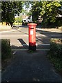
Talbot Woods: postbox № BH3 331, Glenferness Avenue
A George VI-reign postbox in Glenferness Avenue, with its back to the Cawdor Road junction. These two roads are typical of Talbot Woods in being named after Scottish places.
Image: © Chris Downer
Taken: 2 Jul 2008
0.05 miles
4
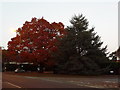
Talbot Woods: evergreen and deciduous in Glenferness Avenue
Two trees stand on a grassy patch at a road junction, one giving an autumnal display of colour while the other stays green. Elgin Road is the sharp right in the foreground, while a car has just turned into Roslin Road South, beyond.
Image: © Chris Downer
Taken: 1 Nov 2010
0.07 miles
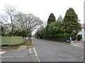
5
Huntly Road, Talbot Woods, Bournemouth
Huntly Road is a residential road in Talbot Woods, a suburb of Bournemouth.
This image was taken on a dull and gloomy February afternoon. The tree on the opposite side of the road had shed its leaves for the winter season.
Image: © Malc McDonald
Taken: 7 Feb 2022
0.09 miles
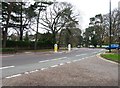
6
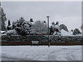
Talbot Woods: winter scene in Roslin Road South
Almost all the roads in the upmarket area of Talbot Woods are named after Scottish places. We look across the junction of Glenferness Avenue and Roslin Road South after Bournemouth's heaviest snow for 17 years fell overnight.
Image: © Chris Downer
Taken: 2 Dec 2010
0.10 miles
7
Elgin Road, Talbot Woods, Bournemouth
Elgin Road is a residential road in Talbot Woods, a suburb of Bournemouth.
In this image, taken on an afternoon in early February, most of the trees on the left hand side of the road have shed their leaves for the winter season while those on the opposite side are evergreens.
Image: © Malc McDonald
Taken: 7 Feb 2022
0.13 miles
8
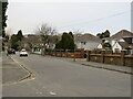
Roslin Road South, Talbot Woods, Bournemouth
Roslin Road South is a residential road in Talbot Woods, a suburb of Bournemouth.
Image: © Malc McDonald
Taken: 7 Feb 2022
0.14 miles
9
Dunkeld Road, Talbot Woods, Bournemouth
Dunkeld Road is a residential road in Talbot Woods, a suburb of Bournemouth.
Image: © Malc McDonald
Taken: 7 Feb 2022
0.15 miles
10
Carrbridge Road, Talbot Woods, Bournemouth
Carrbridge Road is a residential road in Talbot Woods, a suburb of Bournemouth.
Image: © Malc McDonald
Taken: 7 Feb 2022
0.15 miles