IMAGES TAKEN NEAR TO
Dulsie Road, BOURNEMOUTH, BH3 7EA
Introduction
This page details the photographs taken nearby to Dulsie Road, BH3 7EA by members of the Geograph project.
The Geograph project started in 2005 with the aim of publishing, organising and preserving representative images for every square kilometre of Great Britain, Ireland and the Isle of Man.

There are currently over 7.5m images from over14,400 individuals and you can help contribute to the project by visiting https://www.geograph.org.uk
Image Map
Images are licensed for reuse under creativecommons.org/licenses/by-sa/2.0
Notes
- Clicking on the map will re-center to the selected point.
- The higher the marker number, the further away the image location is from the centre of the postcode.
Image Listing (54 Images Found)
Images are licensed for reuse under creativecommons.org/licenses/by-sa/2.0
Image
Details
Distance
1
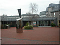
Bournemouth University, sculpture
On the Talbot Campus, next to LearnHigher Centre; granite, partially metallised.
Image: © Mike Faherty
Taken: 4 Jan 2009
0.10 miles
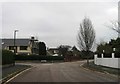
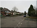
3
Dulsie Rd
Dulsie Rd is a long residential street consisting mainly of large bungalows such as these.
Image: © Nigel Mykura
Taken: 8 May 2012
0.15 miles
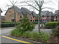
4
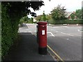
Talbot Woods: postbox № BH3 363, Carrbridge Road
As with almost all the roads in the upmarket suburb of Talbot Woods, Carrbridge Road is named after a Scottish placename. A large drop box (see below) stands immediately behind the postbox.
Image: © Chris Downer
Taken: 23 Aug 2008
0.15 miles
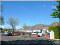
5
Talbot Village, Highmoor Farm
One of originally six small farms in Talbot Village Image, Highmoor is the last functioning. Stocks sheep & cattle.
Image: © Mike Faherty
Taken: 6 Jan 2009
0.16 miles
6
Conference Building at Bournemouth Arts University
This building was used on 9th/10th April 2011 for an exhibition of young art - sponsoring Cancer Research UK - several hundred Dorset schoolchildren participated.
Image: © Peter Beaven
Taken: 10 Apr 2011
0.16 miles
7
Bournemouth University Students' Village
Shared housing development for 250 students on the Talbot Campus. For more information, see http://www.bournemouth.ac.uk/accommodation/student_village.html
Image: © Mike Faherty
Taken: 4 Jan 2009
0.16 miles
8
Huntly Road, Talbot Woods, Bournemouth
Huntly Road is a residential road in Talbot Woods, a suburb of Bournemouth.
This image was taken on a dull and gloomy February afternoon. The tree on the opposite side of the road had shed its leaves for the winter season.
Image: © Malc McDonald
Taken: 7 Feb 2022
0.17 miles
9
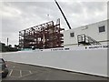
Poole Gateway Building under construction, Bournemouth University
This is being built on the site of the demolished Tolpuddle House.
Image: © Jonathan Hutchins
Taken: 4 Jul 2018
0.18 miles
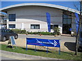
10
Poole : Bournemouth University
Bournemouth University has departments including The School of Health and Social Care, The School of Services Management, The Business School, School of Design, Engineering & Computing and the Media School, recognised as the only Centre for Excellence in Media Practice.
Image: © Lewis Clarke
Taken: 20 Feb 2009
0.18 miles