IMAGES TAKEN NEAR TO
Roslin Gardens, BOURNEMOUTH, BH3 7DR
Introduction
This page details the photographs taken nearby to Roslin Gardens, BH3 7DR by members of the Geograph project.
The Geograph project started in 2005 with the aim of publishing, organising and preserving representative images for every square kilometre of Great Britain, Ireland and the Isle of Man.

There are currently over 7.5m images from over14,400 individuals and you can help contribute to the project by visiting https://www.geograph.org.uk
Image Map
Images are licensed for reuse under creativecommons.org/licenses/by-sa/2.0
Notes
- Clicking on the map will re-center to the selected point.
- The higher the marker number, the further away the image location is from the centre of the postcode.
Image Listing (75 Images Found)
Images are licensed for reuse under creativecommons.org/licenses/by-sa/2.0
Image
Details
Distance
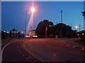
2
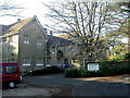
Bournemouth, Talbot Manor.
Built in 1890 as memorial to his aunt, Marianne Talbot, of nearby Talbot Village fame, by Lord Leven & Melville as a boys' home; in use as such until 1974, when it became a care home for adults with physical disabilities. http://www.hiddenlives.org.uk/homes/BOURN01.html http://www.livability.org.uk/page.asp?tip=1&id=1217
Image: © Mike Faherty
Taken: 6 Jan 2009
0.06 miles
3
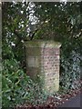
Old Boundary Marker by the A347, Talbot Avenue, Bournemouth
Parish Boundary Marker by the A347, in parish of Bournemouth (Bournemouth District), Talbot Avenue, Talbot Woods, just East of Boundary Roundabout on verge.
Inscription reads:-
: COUNTY OF DORSET : : PARISH OF HOLDENHURST :
Grade II listed.
List Entry Number: 1324774 https://historicengland.org.uk/listing/the-list/list-entry/1324774
Surveyed
Milestone Society National ID: HA_HOLDO01pb
Image: © Milestone Society
Taken: Unknown
0.08 miles
4
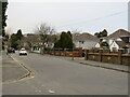
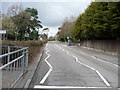
Roslin Road South, Talbot Woods, Bournemouth
Roslin Road South is a residential road in Talbot Woods, a suburb of Bournemouth.
Image: © Malc McDonald
Taken: 7 Feb 2022
0.09 miles
5
Bournemouth : Talbot Avenue
Talbot Avenue looking towards Boundary Roundabout. There is a bus stop on the right here which provides buses to Boscombe and the town centre.
Image: © Lewis Clarke
Taken: 27 Mar 2009
0.09 miles
6
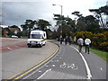
Bournemouth : Boundary Roundabout
An 'old school' ambulance drives around Boundary Roundabout. Students from the university are also seen walking home.
Image: © Lewis Clarke
Taken: 27 Mar 2009
0.09 miles
7
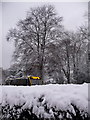
Talbot Woods: hedge and bus on a snowy Talbot Avenue
Partly obscured by the central reservation hedge, we look from queuing traffic on the eastbound carriageway towards a westbound no.6 bus, on its journey from Bournemouth town centre to the northwestern suburbs. Overnight we had the town's heaviest snowfall for 17 years
Image: © Chris Downer
Taken: 2 Dec 2010
0.10 miles
8
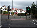
Bournemouth : Talbot Avenue Road Crossing
Waiting for the traffic lights to go green so it's safe to cross the road.
Image: © Lewis Clarke
Taken: 27 Mar 2009
0.10 miles
9
Bournemouth : Boundary Roundabout & Bournemouth University
Boundary Roundabout and an entrance to the rear of Bournemouth University's Talbot Campus.
Image: © Lewis Clarke
Taken: 6 Jun 2008
0.10 miles
10
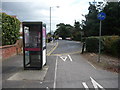
Bournemouth : Talbot Road
Talbot Road with a phone booth and place for cars to turn around as there's a separate turning for them to get onto Talbot Avenue.
Image: © Lewis Clarke
Taken: 27 Mar 2009
0.11 miles