IMAGES TAKEN NEAR TO
Nairn Road, BOURNEMOUTH, BH3 7BE
Introduction
This page details the photographs taken nearby to Nairn Road, BH3 7BE by members of the Geograph project.
The Geograph project started in 2005 with the aim of publishing, organising and preserving representative images for every square kilometre of Great Britain, Ireland and the Isle of Man.

There are currently over 7.5m images from over14,400 individuals and you can help contribute to the project by visiting https://www.geograph.org.uk
Image Map
Images are licensed for reuse under creativecommons.org/licenses/by-sa/2.0
Notes
- Clicking on the map will re-center to the selected point.
- The higher the marker number, the further away the image location is from the centre of the postcode.
Image Listing (14 Images Found)
Images are licensed for reuse under creativecommons.org/licenses/by-sa/2.0
Image
Details
Distance
1
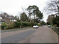
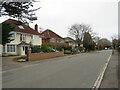
Nairn Road, Talbot Woods, Bournemouth
Nairn Road is a residential road in Talbot Woods, a suburb of Bournemouth.
Image: © Malc McDonald
Taken: 7 Feb 2022
0.05 miles
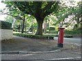
2
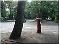
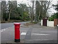
Talbot Woods: postbox № BH3 183, Oban Road
This postbox stands on the corner of the busy Talbot Avenue, the A347 between Bournemouth and Wimborne, and Oban Road. Apart from the original roads Talbot Avenue and East Avenue, the roads in Talbot Woods are named after Scottish towns.
Image: © Chris Downer
Taken: 2 Jul 2008
0.08 miles
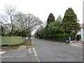
3
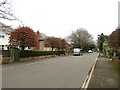
Dunkeld Road, Talbot Woods, Bournemouth
Dunkeld Road is a residential road in Talbot Woods, a suburb of Bournemouth.
Image: © Malc McDonald
Taken: 7 Feb 2022
0.10 miles
4
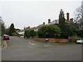
Bournemouth : East Avenue
A morning view of East Avenue
Image: © Lewis Clarke
Taken: 6 Jun 2008
0.14 miles
5
Dunkeld Road, Talbot Woods, Bournemouth
Dunkeld Road is a residential road in Talbot Woods, a suburb of Bournemouth.
Image: © Malc McDonald
Taken: 7 Feb 2022
0.15 miles
6
Oban Road, Winton, Bournemouth
Oban Road is a residential road in Winton, a suburb of Bournemouth.
Image: © Malc McDonald
Taken: 7 Feb 2022
0.18 miles
7
Bournemouth, East Avenue postbox
Edward VII postbox at the junction of East Avenue & Kinross Road.
Image: © Mike Faherty
Taken: 22 Feb 2009
0.18 miles
8
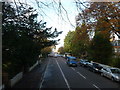
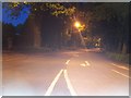
Bournemouth : Winton - Wimborne Road
Taken from the top deck of a double decker bus.
Image: © Lewis Clarke
Taken: 20 Nov 2009
0.19 miles
9
Talbot Woods: postbox № BH3 214, East Avenue
This Edward VII-reign postbox stands on East Avenue, on the corner of a small cul-de-sac, Kinross Road. Apart from the original thoroughfares East Avenue and Talbot Avenue, the roads in Talbot Woods are named after Scottish places.
Image: © Chris Downer
Taken: 2 Jul 2008
0.20 miles
10
Elgin Road, Talbot Woods, Bournemouth
Elgin Road is a residential road in Talbot Woods, a suburb of Bournemouth.
In this image, taken on an afternoon in early February, most of the trees on the left hand side of the road have shed their leaves for the winter season while those on the opposite side are evergreens.
Image: © Malc McDonald
Taken: 7 Feb 2022
0.21 miles