IMAGES TAKEN NEAR TO
The Lea, VERWOOD, BH31 6XN
Introduction
This page details the photographs taken nearby to The Lea, BH31 6XN by members of the Geograph project.
The Geograph project started in 2005 with the aim of publishing, organising and preserving representative images for every square kilometre of Great Britain, Ireland and the Isle of Man.

There are currently over 7.5m images from over14,400 individuals and you can help contribute to the project by visiting https://www.geograph.org.uk
Image Map (Loading...)


Getting Data...Please wait
Leaflet Map data © OpenStreetMap
Images are licensed for reuse under creativecommons.org/licenses/by-sa/2.0
Notes
- Clicking on the map will re-center to the selected point.
- The higher the marker number, the further away the image location is from the centre of the postcode.
Image Listing (6 Images Found)
Images are licensed for reuse under creativecommons.org/licenses/by-sa/2.0
Image
Details
Distance
1
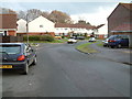
Verwood residential area
Verwood is one of the fastest-growing places in east Dorset.
Image: © Stuart Buchan
Taken: 22 Dec 2005
0.14 miles
2
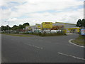
Verwood, builders' merchant
On Blackhill; according to the sign Bradfords was founded in 1770. http://www.bradfords.co.uk/bradfords.php
Image: © Mike Faherty
Taken: 20 Jun 2009
0.19 miles
3
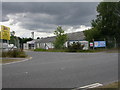
Verwood Industrial Estate
Part of the estate on Blackhill.
Image: © Mike Faherty
Taken: 20 Jun 2009
0.19 miles
4
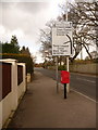
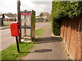
Verwood: postbox № BH31 71, Ringwood Road
This postbox, by the corner of Lake Road, is emptied at 5pm on weekdays and at 7:30am on Saturdays.
Image: © Chris Downer
Taken: 29 Mar 2009
0.22 miles
5
Verwood: postbox № BH31 163, Claylake Drive
The postbox is emptied at 4pm on weekdays and at 8:30 on Saturday mornings.
Image: © Chris Downer
Taken: 29 Mar 2009
0.23 miles
6
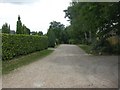
Verwood, Southernhay Road
Un-madeup road from Ringwood Road towards Boveridge Heath.
Image: © Mike Faherty
Taken: 20 Jun 2009
0.23 miles