IMAGES TAKEN NEAR TO
Acacia Avenue, VERWOOD, BH31 6XG
Introduction
This page details the photographs taken nearby to Acacia Avenue, BH31 6XG by members of the Geograph project.
The Geograph project started in 2005 with the aim of publishing, organising and preserving representative images for every square kilometre of Great Britain, Ireland and the Isle of Man.

There are currently over 7.5m images from over14,400 individuals and you can help contribute to the project by visiting https://www.geograph.org.uk
Image Map (Loading...)


Getting Data...Please wait
Leaflet Map data © OpenStreetMap
Images are licensed for reuse under creativecommons.org/licenses/by-sa/2.0
Notes
- Clicking on the map will re-center to the selected point.
- The higher the marker number, the further away the image location is from the centre of the postcode.
Image Listing (6 Images Found)
Images are licensed for reuse under creativecommons.org/licenses/by-sa/2.0
Image
Details
Distance
1
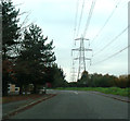
Black Moor Road, Verwood
Near the Ebblake Trading Estate, electricity pylons dominate the skyline.
Image: © Peter Kazmierczak
Taken: 6 Nov 2011
0.07 miles
2
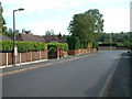
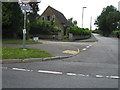
Verwood, Dorset
Residential area; Woodlinken Drive.
Image: © Stuart Buchan
Taken: 11 Jun 2006
0.17 miles
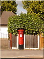
3
Verwood: postbox № BH31 219, The Chase
This postbox is given the number BH21 219 on the Royal Mail's list of postboxes – suggesting a BH21 postcode rather than BH31. The list correctly locates it as 'The Chase' but suggests the Canford Magna area 10 miles or so southwest. It has therefore taken me a good while to track it down! Verwood did come under BH21 (Wimborne) until March 1991 when the Royal Mail decided it had grown big enough to be a post town in its own right: this portion of BH21 was simply renumbered BH31 with the second half of the postcode remaining the same. (Until then, the BH area went up only to 25.)
The information plate on the box says it is number BH31 17, but even that is wrong because that is the one in Ringwood Road! The postman, assuming he knows where to find it, empties the box finally at 4pm on weekdays and at 7:30am on Saturdays.
Looking down The Chase, we see that its old concrete lampposts are being replaced by new metal ones, with three new ones covering the distance of two old ones. To the left, we see old and new side-by-side.
Image: © Chris Downer
Taken: 8 Nov 2009
0.21 miles
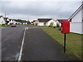
4
Verwood: postbox № BH31 62, Woodlinken Drive
This postbox is situated such that it has necessitated a gap in the fence, which has been done well. The box is emptied at 4:30pm on weekdays and at 8:15am on Saturdays.
Image: © Chris Downer
Taken: 29 Mar 2009
0.21 miles
6
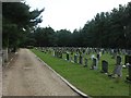
Verwood Cemetery
Off Ringwood Road, surrounded by strips of coniferous woodland on all sides, no doubt as a shield, and also allowing for future expansion. The earliest graves seem to date from the 1960s.
Image: © Mike Faherty
Taken: 24 Jul 2009
0.23 miles