IMAGES TAKEN NEAR TO
Bridleways, VERWOOD, BH31 6LA
Introduction
This page details the photographs taken nearby to Bridleways, BH31 6LA by members of the Geograph project.
The Geograph project started in 2005 with the aim of publishing, organising and preserving representative images for every square kilometre of Great Britain, Ireland and the Isle of Man.

There are currently over 7.5m images from over14,400 individuals and you can help contribute to the project by visiting https://www.geograph.org.uk
Image Map (Loading...)


Getting Data...Please wait
Leaflet Map data © OpenStreetMap
Images are licensed for reuse under creativecommons.org/licenses/by-sa/2.0
Notes
- Clicking on the map will re-center to the selected point.
- The higher the marker number, the further away the image location is from the centre of the postcode.
Image Listing (13 Images Found)
Images are licensed for reuse under creativecommons.org/licenses/by-sa/2.0
Image
Details
Distance
4
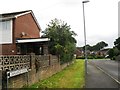
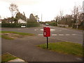
Verwood: postbox № BH31 193, Margards Lane
This postbox is on the northern junction of Hayward Crescent and is emptied at 4pm on weekdays and at 7 o'clock on Saturday mornings.
Image: © Chris Downer
Taken: 29 Mar 2009
0.13 miles
5
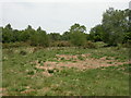
Verwood, Dewlands Common
Local nature reserve & SSSI owned by East Dorset District Council; heathland, pond, woodland. http://www.dorsetforyou.com/index.jsp?articleid=346155
Image: © Mike Faherty
Taken: 25 May 2009
0.14 miles
6
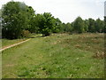
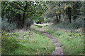
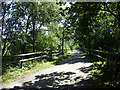
Dewlands Common, footpath
Footpath from Dewlands Road to Bridleways, across Dewlands Common. http://www.dorsetforyou.com/index.jsp?articleid=346155
Image: © Mike Faherty
Taken: 25 May 2009
0.16 miles
8
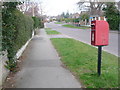
Verwood: postbox № BH31 164, Dewlands Road
This postbox is at the junction of Dewlands Road and Way. It is emptied finally at 4pm on weekdays (the same as the large box on Station Road a little north) and at 9am on Saturdays (1½ hours later than the Station Road box).
Image: © Chris Downer
Taken: 29 Mar 2009
0.21 miles
9
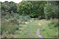
Verwood, Doe's Lane
Near the Eastern end of the right of way from Dewlands to Woodlands Commons.
Image: © Mike Faherty
Taken: 25 May 2009
0.23 miles
10
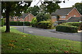
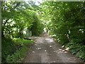
Margards Lane, Verwood
The track (it seems to have no other status) leads to Howe Lane and terminates at St Michael's Road a little over a kilometre further on. To the left, out of view, is Dewlands Road http://www.geograph.org.uk/photo/1449265
Image: © Brian Robert Marshall
Taken: 19 Aug 2009
0.23 miles