IMAGES TAKEN NEAR TO
Meadow Way, VERWOOD, BH31 6HQ
Introduction
This page details the photographs taken nearby to Meadow Way, BH31 6HQ by members of the Geograph project.
The Geograph project started in 2005 with the aim of publishing, organising and preserving representative images for every square kilometre of Great Britain, Ireland and the Isle of Man.

There are currently over 7.5m images from over14,400 individuals and you can help contribute to the project by visiting https://www.geograph.org.uk
Image Map (Loading...)


Getting Data...Please wait
Leaflet Map data © OpenStreetMap
Images are licensed for reuse under creativecommons.org/licenses/by-sa/2.0
Notes
- Clicking on the map will re-center to the selected point.
- The higher the marker number, the further away the image location is from the centre of the postcode.
Image Listing (3 Images Found)
Images are licensed for reuse under creativecommons.org/licenses/by-sa/2.0
Image
Details
Distance
1
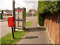
Verwood: postbox № BH31 163, Claylake Drive
The postbox is emptied at 4pm on weekdays and at 8:30 on Saturday mornings.
Image: © Chris Downer
Taken: 29 Mar 2009
0.15 miles
2
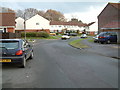
Verwood residential area
Verwood is one of the fastest-growing places in east Dorset.
Image: © Stuart Buchan
Taken: 22 Dec 2005
0.16 miles
3

Verwood: postbox № BH31 211, Woodlinken Drive
This postbox is at the western end of Woodlinken Drive, and is emptied finally at 4pm on weekdays and at 8:15 on Saturday mornings.
Image: © Chris Downer
Taken: 29 Mar 2009
0.23 miles