IMAGES TAKEN NEAR TO
Manor Road, VERWOOD, BH31 6DX
Introduction
This page details the photographs taken nearby to Manor Road, BH31 6DX by members of the Geograph project.
The Geograph project started in 2005 with the aim of publishing, organising and preserving representative images for every square kilometre of Great Britain, Ireland and the Isle of Man.

There are currently over 7.5m images from over14,400 individuals and you can help contribute to the project by visiting https://www.geograph.org.uk
Image Map
Images are licensed for reuse under creativecommons.org/licenses/by-sa/2.0
Notes
- Clicking on the map will re-center to the selected point.
- The higher the marker number, the further away the image location is from the centre of the postcode.
Image Listing (8 Images Found)
Images are licensed for reuse under creativecommons.org/licenses/by-sa/2.0
Image
Details
Distance
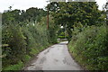
2
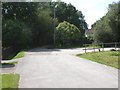
Verwood, lane junction
From behind, St. Michael's Road, which becomes a bridleway to the front; Howe Lane to the right.
Image: © Mike Faherty
Taken: 14 Aug 2009
0.10 miles
3
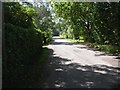
Verwood, St. Michael's Road
Road off Manor Road (B3072) to Howe Lane & Verwood Manor Farm.
Image: © Mike Faherty
Taken: 14 Aug 2009
0.11 miles
5
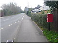
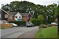
Verwood: postbox № BH31 79, Manor Road
This postbox is emptied finally at 4pm on weekdays and at 7am on Saturdays. Manor Road is the B3072 towards Three Legged Cross and West Moors.
Image: © Chris Downer
Taken: 29 Mar 2009
0.20 miles
7
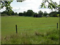
Verwood, paddocks
Much of former agricultural land South of Verwood is now used as paddocks.
Image: © Mike Faherty
Taken: 14 Aug 2009
0.23 miles
8
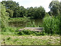
Verwood, angling platform
Platform on the westerly of two lakes here, with rights owned by Christchurch Angling Club. http://christchurchac.org.uk/index.php?option=com_content&task=view&id=98&Itemid=127
Image: © Mike Faherty
Taken: 14 Aug 2009
0.24 miles