IMAGES TAKEN NEAR TO
Naish Estate, Christchurch Road, BH25 7RQ
Introduction
This page details the photographs taken nearby to Naish Estate, Christchurch Road, BH25 7RQ by members of the Geograph project.
The Geograph project started in 2005 with the aim of publishing, organising and preserving representative images for every square kilometre of Great Britain, Ireland and the Isle of Man.

There are currently over 7.5m images from over14,400 individuals and you can help contribute to the project by visiting https://www.geograph.org.uk
Image Map
Images are licensed for reuse under creativecommons.org/licenses/by-sa/2.0
Notes
- Clicking on the map will re-center to the selected point.
- The higher the marker number, the further away the image location is from the centre of the postcode.
Image Listing (29 Images Found)
Images are licensed for reuse under creativecommons.org/licenses/by-sa/2.0
Image
Details
Distance
1
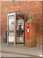
Barton on Sea: postbox № BH25 124 and phone, Bartonside Road
This Edward VII-reign postbox is set into the wall of the Image and serves the fairly vast Hoburne mobile homes and holiday park. It is emptied at 4pm on weekdays and at 8am on Saturdays.
Image: © Chris Downer
Taken: 13 Apr 2009
0.03 miles
2

Barton on Sea: old warehouse type building, Hoburne Park
This old building is now the centre of the Hoburne mobile homes park, along with reception area, club, bar and general store. There is evidence of old wording painted on the front but it is not easy to decipher what it once said.
Image: © Chris Downer
Taken: 13 Apr 2009
0.03 miles
3
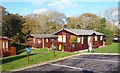
Holiday Lodges at Naish Park
In addition to static caravans, this holiday park has many wooden lodges or chalets.
Image: © mike smith
Taken: 27 Nov 2011
0.03 miles
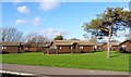
4
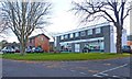
Pub and Supermarket at Naish Park
This large holiday park has its own pub and grocery store, as well as the usual leisure facilities.
Image: © mike smith
Taken: 27 Nov 2011
0.07 miles
5
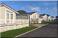
Holiday Homes at Naish Park
This large holiday park is adjacent to the crumbling cliff edge.
Image: © mike smith
Taken: 27 Nov 2011
0.10 miles
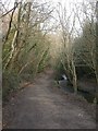
6
Chewton Bunny ? county boundary since 1974
This unremarkable stream became slightly more noteworthy on 1 April 1974 when it became the boundary between Hampshire and Dorset.
Image: © Chris Downer
Taken: Unknown
0.13 miles
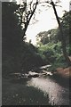
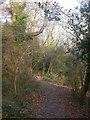
7
Chewton Bunny
The path follows the stream through woods - this is a view looking south west.
Image: © Stephen Williams
Taken: 19 Jun 2007
0.13 miles
8
Chalets at Naish Park
In addition to the more usual mobile homes, this holiday park has a large number of wooden chalets or lodges.
Image: © mike smith
Taken: 27 Nov 2011
0.13 miles
9
Chewton Bunny, Walkford Brook
The brook flows south from near Bransgore, and discharges into the sea 300m south of here. For most of its length from the A337 to the sea, it can be followed by footpath. Bunny is a local word for valley; here, the valley is wooded, mainly oak, beech & holly.
Image: © Mike Faherty
Taken: 30 Dec 2008
0.14 miles
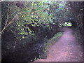
10
Chewton Bunny, footpath
For the length of Walkford Brook from the A337 to the sea a footpath roughly follows the brook, through a wooded valley of oak, beech and holly.
Image: © Mike Faherty
Taken: 30 Dec 2008
0.16 miles