IMAGES TAKEN NEAR TO
Marine Drive West, NEW MILTON, BH25 7QN
Introduction
This page details the photographs taken nearby to Marine Drive West, BH25 7QN by members of the Geograph project.
The Geograph project started in 2005 with the aim of publishing, organising and preserving representative images for every square kilometre of Great Britain, Ireland and the Isle of Man.

There are currently over 7.5m images from over14,400 individuals and you can help contribute to the project by visiting https://www.geograph.org.uk
Image Map
Images are licensed for reuse under creativecommons.org/licenses/by-sa/2.0
Notes
- Clicking on the map will re-center to the selected point.
- The higher the marker number, the further away the image location is from the centre of the postcode.
Image Listing (25 Images Found)
Images are licensed for reuse under creativecommons.org/licenses/by-sa/2.0
Image
Details
Distance
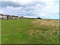

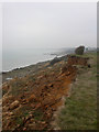
4
The western end of Marine Drive West, Barton on Sea
The houses look out to the sea. The road is part of E9 long distance path
Image: © David Smith
Taken: 29 Mar 2017
0.07 miles
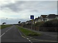
5

Barton Cliff gate to Naish Holiday Park
Image: © Stuart Logan
Taken: 7 Aug 2013
0.07 miles
6
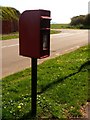
Barton on Sea: postbox № BH25 119, Western Avenue
This postbox is emptied at 5:15pm on weekdays and at 11:45am on Saturdays. Beyond it, we look across the southern end of Western Avenue and can glimpse The Needles in the distance.
Image: © Chris Downer
Taken: 13 Apr 2009
0.08 miles
7
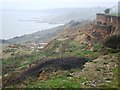
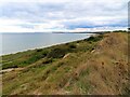
Erosion at Barton.
Stopping at the end of West Parade, Barton, you can see that the cliff edge is falling away.
Image: © Gillian Thomas
Taken: 19 Feb 2007
0.11 miles
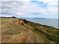
9
Barton on Sea, coastal erosion
The cliffs at Barton have been eroding for centuries, caused by waterlogged soil and possibly hastened by acres of concrete used in house building in the last century. For a comprehensive account, see Ian West's site: http://www.soton.ac.uk/~imw/Barton-Erosion-History.htm
Image: © Mike Faherty
Taken: 31 Dec 2008
0.14 miles
10
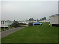
Barton on Sea, Naish Holiday Village
There is a variety of different sorts of accommodation on this large site. For more details, see: http://www.hoseasons.co.uk/v3/Webpages/UKPark/ProductDetailPage.aspx?ISDLNK=1&SCODE=NAIS&TIDPDUKPARK=parkInfo&ISPKMD=true&_$ja=kw:Hoburne+Naish
Image: © Mike Faherty
Taken: 31 Dec 2008
0.17 miles