IMAGES TAKEN NEAR TO
Station Road, NEW MILTON, BH25 6HY
Introduction
This page details the photographs taken nearby to Station Road, BH25 6HY by members of the Geograph project.
The Geograph project started in 2005 with the aim of publishing, organising and preserving representative images for every square kilometre of Great Britain, Ireland and the Isle of Man.

There are currently over 7.5m images from over14,400 individuals and you can help contribute to the project by visiting https://www.geograph.org.uk
Image Map
Images are licensed for reuse under creativecommons.org/licenses/by-sa/2.0
Notes
- Clicking on the map will re-center to the selected point.
- The higher the marker number, the further away the image location is from the centre of the postcode.
Image Listing (81 Images Found)
Images are licensed for reuse under creativecommons.org/licenses/by-sa/2.0
Image
Details
Distance
1
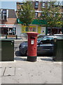
New Milton: postbox № BH25 121, Station Road
A fat, Elizabeth II-reign postbox on the western side of the town's main street. It is emptied finally at 5:30pm on weekdays and at 12:15pm on Saturdays.
Image: © Chris Downer
Taken: 21 Jul 2013
0.04 miles
2

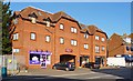
New Milton: Homemill House
A block of retirement flats, centrally located above the shops and pavement of the main Station Road. It was built by McCarthy & Stone retirement living builders, all of whose many blocks nationwide are called Home-something: Homelands, Homeleigh, Homethwaite, Homequay etc. (There are easily a hundred on one website search facility I found.)
Projecting from it is Image, marking New Milton's centenary in 1996.
We look at the building from across the road, under a hanging basket affixed to a lamppost.
Image: © Chris Downer
Taken: 26 Aug 2013
0.05 miles
3
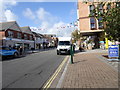
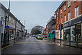
Station Road
The view of high street in New Milton.
Image: © Gordon Griffiths
Taken: 24 Sep 2019
0.05 miles
4
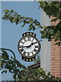
New Milton: centenary clock
A plaque at street level explains, if it isn't obvious from the surrounding dates, that the clock commemorates the town's centenary in 1996. It projects from the wall of Image, a block of retirement flats whose upper floors overhang the pavement of Station Road.
Image: © Chris Downer
Taken: 21 Jul 2013
0.06 miles
5
New Milton Town Hall
Providing services from the town, district & county councils: http://www.copythorne.gov.uk/index.cfm?articleid=7204
Image: © Mike Faherty
Taken: 20 Dec 2008
0.07 miles
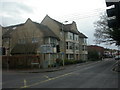
6
Charlotte Court
This attractive apartment block, close to the town centre, was built in 1995.
As can be seen, some small retail units are established at street level.
Image: © mike smith
Taken: 3 Feb 2012
0.07 miles
7
New Milton : Old Milton Road
Looking along Old Milton Road from Station Road.
Image: © Lewis Clarke
Taken: 28 Mar 2018
0.07 miles
8
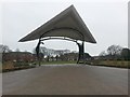
New Milton: the Manta Ray pavilion
Looking diagonally across New Milton recreation ground (Image]) from its back corner towards its main frontage on Ashley Road.
The structure in front of us is the Manta Ray Pavilion, providing a covered performance space and depicting a giant manta ray as if rising from the sea.
Image: © Chris Downer
Taken: 10 Mar 2018
0.08 miles
9

New Milton: across the recreation ground
New Milton rec is in the town centre, just off the High Street. We look across its eastern side here, past an open-air performance space covered by Image
In the background is a graffiti mural which was painted as a memorial to a local young child who fell victim to cancer. See Image for further details.
Image: © Chris Downer
Taken: 10 Mar 2018
0.08 miles
10
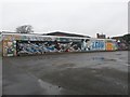
New Milton: a memorial to Leon
This mural was painted across a wall at the back of New Milton recreation ground (Image) as a memorial to a local toddler, Leon Bartholomew, who died of cancer in 2013. It was done by graffiti artist Scott Vincent.
Image: © Chris Downer
Taken: 10 Mar 2018
0.08 miles