IMAGES TAKEN NEAR TO
Longleat Gardens, NEW MILTON, BH25 5XG
Introduction
This page details the photographs taken nearby to Longleat Gardens, BH25 5XG by members of the Geograph project.
The Geograph project started in 2005 with the aim of publishing, organising and preserving representative images for every square kilometre of Great Britain, Ireland and the Isle of Man.

There are currently over 7.5m images from over14,400 individuals and you can help contribute to the project by visiting https://www.geograph.org.uk
Image Map
Images are licensed for reuse under creativecommons.org/licenses/by-sa/2.0
Notes
- Clicking on the map will re-center to the selected point.
- The higher the marker number, the further away the image location is from the centre of the postcode.
Image Listing (10 Images Found)
Images are licensed for reuse under creativecommons.org/licenses/by-sa/2.0
Image
Details
Distance
1
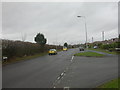
New Milton, Stem Lane
Stem Lane forms the boundary between green belt farmland, to the left, and New Milton housing, to the right.
Image: © Mike Faherty
Taken: 20 Dec 2008
0.13 miles
2
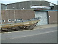
Industrial Estate, New Milton
The Sunseeker unit produces the hull mouldings for their very prestigious boats.
Image: © Stuart Buchan
Taken: 4 Aug 2005
0.14 miles
3
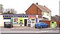
Convenience Store on Beechwood Avenue
This corner shop includes a post office in addition to the alcohol and general groceries on offer.
Image: © mike smith
Taken: 5 Apr 2012
0.15 miles
4
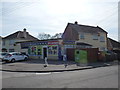
New Milton: Beechwood Avenue Post Office
A McColl's-branded convenience store serving the northern suburb of New Milton, incorporating Beechwood Avenue Post Office. Marley Avenue is the side road to the left.
Image: © Chris Downer
Taken: 25 Mar 2012
0.15 miles
5
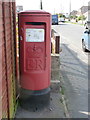
New Milton: postbox № BH25 192, Beechwood Avenue
This 'Type K' postbox - a design from the very late 1970s - stands alongside the forecourt of Image
Image: © Chris Downer
Taken: 25 Mar 2012
0.15 miles
6
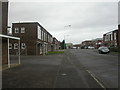
New Milton, Stem Lane Industrial Estate
Typical nondescript industrial estate; Saturday afternoon, not a lot happening outside.
Image: © Mike Faherty
Taken: 20 Dec 2008
0.17 miles
7
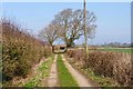
Walkford Lane - Dirt Track Portion
Although this lane is tarmac-surfaced as far as the last house, north of that point is just a dirt track used by farm tractors. Adventurous drivers could follow the track into the busy Stem Lane.
Image: © mike smith
Taken: 12 Mar 2012
0.22 miles
8
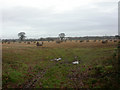
Walkford, bales
Peaceful view of open field with bales; housing in the distance is on Stem Lane Image
Image: © Mike Faherty
Taken: 13 Jan 2009
0.22 miles
9
Walkford Lane - Tarmac to Dirt Track
This is the point where the surfaced lane turns into a dirt track.
It is intriguing to think that until some 70 or 80 years ago, the whole length would have been a dirt track.
Image: © mike smith
Taken: 12 Mar 2012
0.23 miles
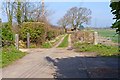
10

The Last House on Walkford Lane
This is the last house on the tarmac portion of Walkford Lane, before it becomes a dirt track.
Image: © mike smith
Taken: 12 Mar 2012
0.24 miles