IMAGES TAKEN NEAR TO
Wootton Rough, NEW MILTON, BH25 5UA
Introduction
This page details the photographs taken nearby to Wootton Rough, BH25 5UA by members of the Geograph project.
The Geograph project started in 2005 with the aim of publishing, organising and preserving representative images for every square kilometre of Great Britain, Ireland and the Isle of Man.

There are currently over 7.5m images from over14,400 individuals and you can help contribute to the project by visiting https://www.geograph.org.uk
Image Map
Images are licensed for reuse under creativecommons.org/licenses/by-sa/2.0
Notes
- Clicking on the map will re-center to the selected point.
- The higher the marker number, the further away the image location is from the centre of the postcode.
Image Listing (5 Images Found)
Images are licensed for reuse under creativecommons.org/licenses/by-sa/2.0
Image
Details
Distance
1
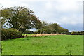
Former field boundary near Bashley
The line of trees no longer forms a continuous barrier between these fields.
Image: © David Martin
Taken: 20 Aug 2018
0.11 miles
2
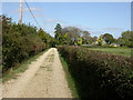
Tiptoe, footpath
Footpath and track from Tiptoe Road to Forest Close (visible to the right), and the open forest.
Image: © Mike Faherty
Taken: 26 Sep 2009
0.20 miles
3
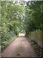
Bashley, Wootton Rough
Footpath and private road from St Johns Road to Tiptoe Road.
Image: © Mike Faherty
Taken: 14 Sep 2010
0.21 miles
5
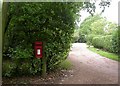
Bashley, pillar postbox
On St Johns Road, EIIR box with ID BH25 194.
Image: © Mike Faherty
Taken: 14 Sep 2010
0.24 miles