IMAGES TAKEN NEAR TO
Sway Road, NEW MILTON, BH25 5QR
Introduction
This page details the photographs taken nearby to Sway Road, BH25 5QR by members of the Geograph project.
The Geograph project started in 2005 with the aim of publishing, organising and preserving representative images for every square kilometre of Great Britain, Ireland and the Isle of Man.

There are currently over 7.5m images from over14,400 individuals and you can help contribute to the project by visiting https://www.geograph.org.uk
Image Map
Images are licensed for reuse under creativecommons.org/licenses/by-sa/2.0
Notes
- Clicking on the map will re-center to the selected point.
- The higher the marker number, the further away the image location is from the centre of the postcode.
Image Listing (5 Images Found)
Images are licensed for reuse under creativecommons.org/licenses/by-sa/2.0
Image
Details
Distance
1
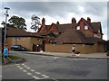
Bashley Park House
Originally built in 1885 this much added to building is now part of a caravan and holiday complex.
Image: © Anthony Vosper
Taken: 6 Aug 2012
0.01 miles
2
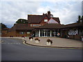
Reception to the Holbourne Bashley caravan complex
Bashley Park, originally built in 1885 is now home to a caravan holiday complex.
Image: © Anthony Vosper
Taken: 6 Aug 2012
0.05 miles
3
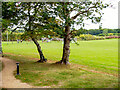
Sports field
At Bashley Park holiday village.
Image: © John Lucas
Taken: 13 Sep 2023
0.13 miles
4
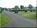
Hoburne - Bashley Park
This 100 acre caravan park is close to the New Forest and the sandy beaches of the Solent.
Image: © Stuart Buchan
Taken: 11 Oct 2005
0.20 miles
5
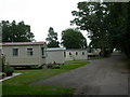
Bashley, holiday park
As seen from the track from St Johns Road. http://www.hoburne.com/park-details/hoburne-bashley?utm_source=google&utm_medium=cpc&utm_term=bashley%20park&utm_campaign=
Image: © Mike Faherty
Taken: 14 Sep 2010
0.21 miles