IMAGES TAKEN NEAR TO
Seaway, NEW MILTON, BH25 5PL
Introduction
This page details the photographs taken nearby to Seaway, BH25 5PL by members of the Geograph project.
The Geograph project started in 2005 with the aim of publishing, organising and preserving representative images for every square kilometre of Great Britain, Ireland and the Isle of Man.

There are currently over 7.5m images from over14,400 individuals and you can help contribute to the project by visiting https://www.geograph.org.uk
Image Map
Images are licensed for reuse under creativecommons.org/licenses/by-sa/2.0
Notes
- Clicking on the map will re-center to the selected point.
- The higher the marker number, the further away the image location is from the centre of the postcode.
Image Listing (7 Images Found)
Images are licensed for reuse under creativecommons.org/licenses/by-sa/2.0
Image
Details
Distance
1
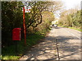
New Milton: postbox № BH25 78, Milford Road
Looking along the B3058 which is, as its name suggests, the road to (or in this direction, from) Milford on Sea. The postbox is emptied at 9am Monday to Saturday.
Image: © Chris Downer
Taken: 13 Apr 2009
0.02 miles
2
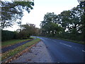
Green Lane View
The view in the New Milton along Milford Road.
Image: © Gordon Griffiths
Taken: 27 Sep 2019
0.15 miles
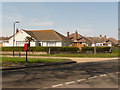
3

Silverdale
Silverdale is the name of the road, containing a development of mid-price homes.
Image: © mike smith
Taken: 5 Dec 2011
0.19 miles
4
New Milton: postbox № BH25 195, Becton Lane
Looking across Becton Lane towards the junction of Ashmore Avenue, where this small postbox is located. It is emptied at 4pm on weekdays and at noon on Saturdays.
Image: © Chris Downer
Taken: 13 Apr 2009
0.20 miles
5
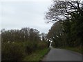
Valley and woodland on Barton Common
The road through the woodland drops to cross a shallow valley formed by a stream which joins the stream near Becton Bunny
Image: © David Smith
Taken: 29 Mar 2017
0.24 miles
6
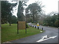
Barton on Sea, Durlston Court School
No local primary school, this! Why it should be named after a location 26km away (as the crow flies), I didn't know, until an answer came back: John Teather reports that the school was originally at Durlston Head, but had to be relocated because of WW2 damage; after the war, it was re-established here. http://www.durlstoncourt.co.uk/
Image: © Mike Faherty
Taken: 20 Dec 2008
0.24 miles
7
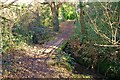
Wooden Footbridge at Barton Common
This footbridge enables walkers to cross a small stream in woodland on Barton Common.
The timbers appear to be old railway sleepers.
Image: © mike smith
Taken: 16 Jan 2012
0.25 miles