IMAGES TAKEN NEAR TO
Keswick Road, NEW MILTON, BH25 5JA
Introduction
This page details the photographs taken nearby to Keswick Road, BH25 5JA by members of the Geograph project.
The Geograph project started in 2005 with the aim of publishing, organising and preserving representative images for every square kilometre of Great Britain, Ireland and the Isle of Man.

There are currently over 7.5m images from over14,400 individuals and you can help contribute to the project by visiting https://www.geograph.org.uk
Image Map
Images are licensed for reuse under creativecommons.org/licenses/by-sa/2.0
Notes
- Clicking on the map will re-center to the selected point.
- The higher the marker number, the further away the image location is from the centre of the postcode.
Image Listing (21 Images Found)
Images are licensed for reuse under creativecommons.org/licenses/by-sa/2.0
Image
Details
Distance
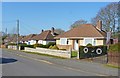
1
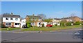
Housing Estate at Ferndale Road
This is typical of the homes that were built in this area during the 1970s and 1980s.
Image: © mike smith
Taken: 3 Apr 2012
0.05 miles
2
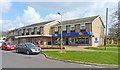
Ferndale Stores
This general store includes a post office as well. Next door is a hair dressers.
Image: © mike smith
Taken: 3 Apr 2012
0.09 miles
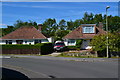
3
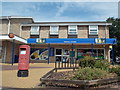
New Milton: Ferndale Road Post Office and postbox № BH25 203
The post office is within a newsagent and general store, the end one of a parade of three shops - next door is a ladies' hairdresser and the third shop appears to have been converted to residential.
Ferndale Road Post Office opened on 26 July 1993 as a replacement for the nearby Manor Road branch, which had closed nine months previously (see Image).
Image: © Chris Downer
Taken: 28 Jul 2013
0.10 miles
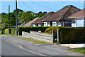
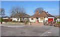
5
Bungalows on Marston Road
These older-styled bungalows are in contrast to the major developments in the area made during the 1970s and 1980s.
Image: © mike smith
Taken: 3 Apr 2012
0.10 miles
7
Bungalows on Charles Crescent
These older-styled bungalows are in contrast to the major developments in the area made during the 1970s and 1980s.
Image: © mike smith
Taken: 3 Apr 2012
0.14 miles
8
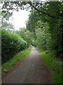
Bashley, Cull Lane
One of the area's few historic roads, now blocked by housing development and at Sway Lane.
Image: © Mike Faherty
Taken: 14 Sep 2010
0.15 miles
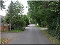
9
Bashley, footpath & cycleway
Between housing developments.
Image: © Mike Faherty
Taken: 14 Sep 2010
0.16 miles
10
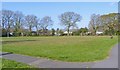
Amenity Green
This green is a welcome feature in the middle of a massive residential development which took place in the area during the 1970s and 1980s.
Image: © mike smith
Taken: 3 Apr 2012
0.16 miles