IMAGES TAKEN NEAR TO
BH24 9FD
Introduction
This page details the photographs taken nearby to BH24 9FD by members of the Geograph project.
The Geograph project started in 2005 with the aim of publishing, organising and preserving representative images for every square kilometre of Great Britain, Ireland and the Isle of Man.

There are currently over 7.5m images from over14,400 individuals and you can help contribute to the project by visiting https://www.geograph.org.uk
Image Map
Images are licensed for reuse under creativecommons.org/licenses/by-sa/2.0
Notes
- Clicking on the map will re-center to the selected point.
- The higher the marker number, the further away the image location is from the centre of the postcode.
Image Listing (29 Images Found)
Images are licensed for reuse under creativecommons.org/licenses/by-sa/2.0
Image
Details
Distance
1
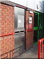
Ringwood: postbox № BH24 2000, Headlands Business Park
This postbox is set into the wall of the Image and unsurprisingly has the latest collection times in the town - it is emptied finally at 6pm on weekdays and at 1pm on Saturdays.
For some curious reason, the postbox at the sorting office or main post office seems to be often numbered 2000, despite others in the area being numbered randomly but upwards from 1.
Image: © Chris Downer
Taken: 20 Mar 2011
0.01 miles
2
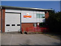
Ringwood: Royal Mail delivery office
The LOD (Local Delivery Office) for Ringwood, serving the BH24 postal area, is housed in one of the units of Headlands Business Park, a small out-of-town industrial estate on the northern edge of town.
Image: © Chris Downer
Taken: 20 Mar 2011
0.04 miles
3
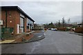
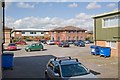
Blashford, business park
Headlands Business Park, off Salisbury Road.
Image: © Mike Faherty
Taken: 12 Feb 2011
0.04 miles
4
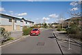
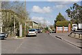
Part of Headlands Business Park, Blashford
Looking across the U-shaped access road from one arm of the U to the other.
Image: © Peter Facey
Taken: 11 Apr 2008
0.07 miles
5
Part of Headlands Business Park, Blashford
The long building on the left is occupied by http://www.eberspacher.com/
Image: © Peter Facey
Taken: 11 Apr 2008
0.07 miles
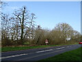
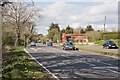
7
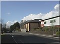
A338 Salisbury Road at Blashford, looking south
Image: © David Martin
Taken: 24 Apr 2016
0.10 miles
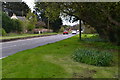
8
Road into Headlands Business Park, Blashford
That's what it says on my street map, but I couldn't see any sign in the real world.
Image: © Peter Facey
Taken: 11 Apr 2008
0.10 miles
9
Watson filling station on A338 at Blashford
A large industrial estate is further right and the access road to it joins the A338 on both sides of this filling station.
Image: © Peter Facey
Taken: 11 Apr 2008
0.11 miles