
IMAGES TAKEN NEAR TO
Bisterne Close, RINGWOOD, BH24 4AU
Introduction
This page details the photographs taken nearby to Bisterne Close, BH24 4AU by members of the Geograph project.
The Geograph project started in 2005 with the aim of publishing, organising and preserving representative images for every square kilometre of Great Britain, Ireland and the Isle of Man.

There are currently over 7.5m images from over14,400 individuals and you can help contribute to the project by visiting https://www.geograph.org.uk
Image Map
Images are licensed for reuse under creativecommons.org/licenses/by-sa/2.0
Notes
- Clicking on the map will re-center to the selected point.
- The higher the marker number, the further away the image location is from the centre of the postcode.
Image Listing (17 Images Found)
Images are licensed for reuse under creativecommons.org/licenses/by-sa/2.0
Image
Details
Distance
1
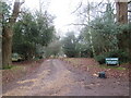
Private driveway near Burley
A private driveway leading to a house in the New Forest, photographed on a dull late December day.
Image: © Malc McDonald
Taken: 28 Dec 2024
0.04 miles
2
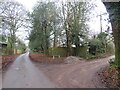
Bisterne Close, New Forest, near Burley
Bisterne Close is a minor lane and rural hamlet in the New Forest National Park, near the village of Burley. The lane leading off to the right is private, but the wooden signpost to the right of the image confirms it is a public right of way as a footpath.
This image was taken on a dull day in late December. Deciduous trees were bare for the winter season.
Image: © Malc McDonald
Taken: 28 Dec 2024
0.04 miles
3
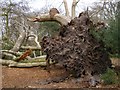
Fallen beech tree, Burley Rocks, New Forest
The soil in the New Forest is generally poor and thin and it is common to see fallen mature trees in the open woodland. This tree must have been down for a few years because the holly bush on the right has had time to grow in the hole left behind. There is an enormous bracket fungus growing on one of the branches.
Image: © Jim Champion
Taken: 12 Apr 2007
0.10 miles
4

Bisterne Close, fallen tree
A beech with hollow trunk has succumbed to wind and lost its main branches; fungi are taking over to complete their task of decomposition.
Image: © Mike Faherty
Taken: 9 Nov 2012
0.12 miles
5
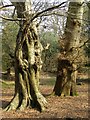
Beech and oak in open woodland, Bisterne Close, New Forest
These two species of deciduous trees dominate the open woodland of the New Forest, and have done for at least a thousand years. There is usually an understorey of holly in this pony- and deer-browsed woodland, as can be seen here behind the trunks of the large trees. Unlike the more recently introduced pines and firs, oak and beech retain their lower branches and can grow more in an effort to repair any damage.
Image: © Jim Champion
Taken: 12 Apr 2007
0.16 miles
6
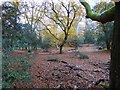
Bisterne Close, woodland
The autumn colour of beeches contrasts well with evergreen holly.
Image: © Mike Faherty
Taken: 9 Nov 2012
0.18 miles
7
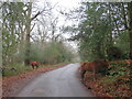
New Forest ponies at Bisterne Close, near Burley
Two New Forest ponies grazing on Bisterne Close, a minor lane in the New Forest National Park near the village of Burley.
This image was taken on a dull day in late December. Deciduous trees were bare for the winter season.
Image: © Malc McDonald
Taken: 28 Dec 2024
0.20 miles
8

Emerging Dragonfly (Orthetrum coerulescens)
This Keeled Skimmer has spent at least 2 years as a larva in the muddy ditches here. It is now emerging from its last larval case as an adult for the last 2 months of its life where it will try to reproduce. The wings come out as tiny stubs that expand as fluid is pumped into the veins. They then open out and dry to become rigid. During this period they are very vulnerable to predation and damage as they can't easily move and the wings and body can be deformed before they are dry.
Image: © Hugh Venables
Taken: 18 Jun 2005
0.21 miles
9
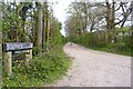
Southfield Lane
This unmade road is labelled "private road" on the name post, but maps indicate that it is a footpath and bridleway.
Image: © mike smith
Taken: 11 Apr 2014
0.21 miles
10
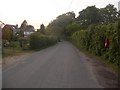
Burley: postbox № BH24 38, Bennetts Lane
This small postbox, almost hiding in a hedge, is emptied at 9 o'clock each morning, except on Sundays.
Image: © Chris Downer
Taken: 18 May 2009
0.21 miles