
IMAGES TAKEN NEAR TO
Linford, RINGWOOD, BH24 3HY
Introduction
This page details the photographs taken nearby to BH24 3HY by members of the Geograph project.
The Geograph project started in 2005 with the aim of publishing, organising and preserving representative images for every square kilometre of Great Britain, Ireland and the Isle of Man.

There are currently over 7.5m images from over14,400 individuals and you can help contribute to the project by visiting https://www.geograph.org.uk
Image Map
Images are licensed for reuse under creativecommons.org/licenses/by-sa/2.0
Notes
- Clicking on the map will re-center to the selected point.
- The higher the marker number, the further away the image location is from the centre of the postcode.
Image Listing (37 Images Found)
Images are licensed for reuse under creativecommons.org/licenses/by-sa/2.0
Image
Details
Distance
1
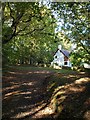
House in the woods, Linford
The edges of the New Forest are characterised by islands of buildings on private land surrounded by access land, and this is one of two such properties near Linford Bottom.
Image: © Derek Harper
Taken: 12 Oct 2009
0.04 miles
2

Towards Linford Bottom
The grassy turf, with areas of bracken, leading down to Linford Brook, with the edge of Great Linford Inclosure on the left.
Image: © Derek Harper
Taken: 12 Oct 2009
0.10 miles
3

Linford, road
Road from Great Linford Cottage down to Linford.
Image: © Mike Faherty
Taken: 21 Aug 2009
0.10 miles
4

Linford, ponies
Ponies grazing on a lawn alongside the road from Great Linford Cottage to Linford.
Image: © Mike Faherty
Taken: 21 Aug 2009
0.11 miles
5
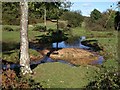
Linford Brook
Looking upstream from a bridge at Linford Green towards Linford Bottom.
Image: © Derek Harper
Taken: 12 Oct 2009
0.11 miles
6

Cottages at Linford, near Ringwood
A pair of semi-detached cottages at Linford, in the New Forest National Park.
Image: © Malc McDonald
Taken: 12 Apr 2025
0.11 miles
7
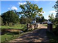
Bridge over Linford Brook
Image: © Derek Harper
Taken: 12 Oct 2009
0.11 miles
8
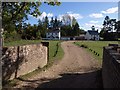
Linford Green
In the foreground is the bridge from which Image was taken, looking to the left. The track, from Linford House, crosses the green towards Linford farmhouse.
Image: © Derek Harper
Taken: 12 Oct 2009
0.13 miles
9

Road from Linford Bottom to Rockford Common
Bridge over Linford Brook in foreground. Turning right goes to car park for Linford bottom. Road straight ahead goes up a steep hill and emerges on Rockford Common. Also connects with top end of Highwood Lane.
Image: © Peter Facey
Taken: 29 May 2006
0.13 miles
10

Linford Bottom
The road is seen in reverse in Image Perhaps the bank in the foreground marks an earlier position of the road edge. The wood beyond the Linford Brook on the left is Little Linford Inclosure.
Image: © Derek Harper
Taken: 12 Oct 2009
0.14 miles