IMAGES TAKEN NEAR TO
Spring Lane, RINGWOOD, BH24 3FH
Introduction
This page details the photographs taken nearby to Spring Lane, BH24 3FH by members of the Geograph project.
The Geograph project started in 2005 with the aim of publishing, organising and preserving representative images for every square kilometre of Great Britain, Ireland and the Isle of Man.

There are currently over 7.5m images from over14,400 individuals and you can help contribute to the project by visiting https://www.geograph.org.uk
Image Map
Images are licensed for reuse under creativecommons.org/licenses/by-sa/2.0
Notes
- Clicking on the map will re-center to the selected point.
- The higher the marker number, the further away the image location is from the centre of the postcode.
Image Listing (52 Images Found)
Images are licensed for reuse under creativecommons.org/licenses/by-sa/2.0
Image
Details
Distance
1
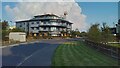
Ringwood - Anytime Fitness premises
Part of an extensive business park south of the town.
Image: © Peter Whatley
Taken: 20 Sep 2024
0.01 miles
2
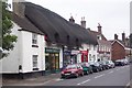
Ringwood, Hants
A view along Christchurch Road towards the town centre
Image: © Ron Strutt
Taken: 15 Aug 2004
0.02 miles

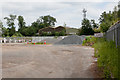
4
New Industrial Area, Ringwood
This industrial area is on the site of the old Ringwood railway station. The photo is taken from the old railway bridge.
Further information on the station and associated railway, including photos of the station before closure, can be found at http://www.disused-stations.org.uk/r/ringwood/index.shtml
Image: © Stuart Buchan
Taken: 17 May 2005
0.07 miles
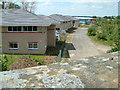
5
Depot of New Forest District Council
Part of. Note the No Tipping sign.
Image: © Peter Facey
Taken: 12 Jun 2010
0.08 miles

7

Evening Primrose, Ringwood
I associate Oenothera biennis with railway sidings and track sides and here it is growing in abundance on wasteland around the site of the former Ringwood station, just off Embankment Way.
Image: © Derek Harper
Taken: 12 Oct 2009
0.11 miles
8
Embankment Way - end of the road
View of the end of Embankment Way on the former railway track bed looking towards the bridge on Crow Arch Lane.
Image: © Mat Tuck
Taken: 3 Nov 2013
0.13 miles
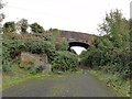
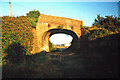
9
Bridge across former railway line, Ringwood
This is the bridge shown in Image seen from the other side, east of the former station.
Image: © Derek Harper
Taken: 12 Oct 2009
0.13 miles
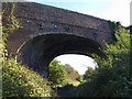
10
Crow Arch
This bridge, known as 'Crow Arch' on the old LSWR 'Castleman's Corkscrew' line near Ringwood is approached by a steeply sloping road on either side - not for the faint-hearted when riding a bike! Immediately past the bridge, the railway entered Ringwood Goods Yard before reaching the station.
Image: © Bob Walters
Taken: 27 Aug 1993
0.13 miles