IMAGES TAKEN NEAR TO
Nouale Lane, RINGWOOD, BH24 3EL
Introduction
This page details the photographs taken nearby to Nouale Lane, BH24 3EL by members of the Geograph project.
The Geograph project started in 2005 with the aim of publishing, organising and preserving representative images for every square kilometre of Great Britain, Ireland and the Isle of Man.

There are currently over 7.5m images from over14,400 individuals and you can help contribute to the project by visiting https://www.geograph.org.uk
Image Map
Images are licensed for reuse under creativecommons.org/licenses/by-sa/2.0
Notes
- Clicking on the map will re-center to the selected point.
- The higher the marker number, the further away the image location is from the centre of the postcode.
Image Listing (36 Images Found)
Images are licensed for reuse under creativecommons.org/licenses/by-sa/2.0
Image
Details
Distance
1
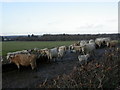
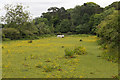
Hightown, cattle
Beef cattle on Nouale Lane, opposite Lynes Farm.
Image: © Mike Faherty
Taken: 8 Jan 2011
0.03 miles
2
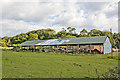
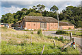
Large barn at Lynes Farm, Nouale Lane, Ringwood
For the brick farm buildings beyond, see Image
Image: © Peter Facey
Taken: 26 Sep 2007
0.04 miles
3
Hightown, barns
Barns ancient and modern at Lynes Farm on Nouale Lane.
Image: © Mike Faherty
Taken: 8 Jan 2011
0.05 miles
4
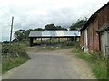
Nouale Lane skirts a barn at Lynes Farm
Image: © Stuart Logan
Taken: 16 Jul 2014
0.06 miles
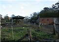
5
Lynes Farm buildings, Nouale Lane, Ringwood
These old buildings are arranged in the traditional U-shape forming a courtyard. An S-bend in Nouale Lane is in front, and Milky Down is behind.
Image: © Peter Facey
Taken: 26 Sep 2007
0.07 miles
6
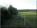
Hightown, footpath
From Nouale Lane to Hightown Road; a horse paddock to the right.
Image: © Mike Faherty
Taken: 8 Jan 2011
0.10 miles
8
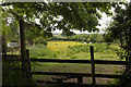
Footpath north of house named White Hall, Nouale Lane
Image: © Peter Facey
Taken: 24 May 2017
0.11 miles
9
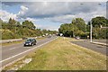
A31 dual carriageway at the foot of Poulner Hill, Ringwood
The turning at the right is to Nouale Lane.
Image: © Peter Facey
Taken: 26 Sep 2007
0.15 miles
10
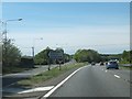
Slip road off westbound A31 for Hightown
The slip road is initially one-way, but becomes two-way, as the turning for Hightown is on the left part way up the slope to the overpass to Poulner
Image: © David Smith
Taken: 3 May 2014
0.15 miles