IMAGES TAKEN NEAR TO
Woolsbridge Road, RINGWOOD, BH24 2LZ
Introduction
This page details the photographs taken nearby to Woolsbridge Road, BH24 2LZ by members of the Geograph project.
The Geograph project started in 2005 with the aim of publishing, organising and preserving representative images for every square kilometre of Great Britain, Ireland and the Isle of Man.

There are currently over 7.5m images from over14,400 individuals and you can help contribute to the project by visiting https://www.geograph.org.uk
Image Map
Images are licensed for reuse under creativecommons.org/licenses/by-sa/2.0
Notes
- Clicking on the map will re-center to the selected point.
- The higher the marker number, the further away the image location is from the centre of the postcode.
Image Listing (18 Images Found)
Images are licensed for reuse under creativecommons.org/licenses/by-sa/2.0
Image
Details
Distance
1
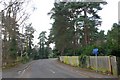
Lions Lane Ashley Heath
Looking SW along the lane from close to the junction with Horton lane.
Image: © Nigel Mykura
Taken: 26 Nov 2008
0.07 miles
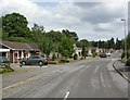
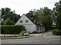
2
Ashley Heath shops
Not a very large parade of shops!
Image: © Stuart Buchan
Taken: 17 May 2005
0.09 miles
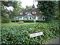
3
Ashley Heath: England?s shortest High Street (reputedly)
This is Ashley Heath High Street, a short road linking Woolsbridge Road and Lions Lane near to their mutual junction.
Image: © Chris Downer
Taken: Unknown
0.10 miles
4
Ashley Heath, Peveril Close
Post-1960s bungalows off Horton Road.
Image: © Mike Faherty
Taken: 8 Aug 2010
0.10 miles
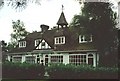
5
Ashley Heath, High Street
Off Horton Road; according to a plaque, Britain's shortest high street. It measures about 40m. Built in the 1920s as part of a garden estate that didn't seem to take off; currently comprising day nursery, pharmacy and hair salon.
Image: © Mike Faherty
Taken: 8 Aug 2010
0.10 miles
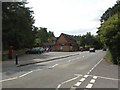
6
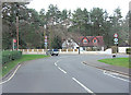
Junction of Woolsbridge Road and Horton Road
Image: © Stuart Logan
Taken: 18 Mar 2012
0.11 miles
7
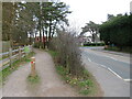
NEW
Castleman Trailway, Ashley Heath, near Ringwood
The Castleman Trailway at Ashley Heath, near Ringwood. Here, it has just crossed a road. As it bends round to the left, it returns to a former railway alignment which it follows for a considerable distance. The railway closed in the 1960s, under the "Beeching cuts".
This section of the trail is also on route 256 of the National Cycle Network.
Image: © Malc McDonald
Taken: 9 Mar 2025
0.13 miles
8
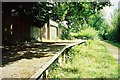
Ashley Heath: old railway platform
This former railway line is now a pleasant forest walk from West Moors to Ringwood.
Image: © Chris Downer
Taken: Unknown
0.13 miles
9
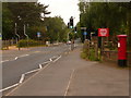
Ashley Heath: postbox № BH24 31, Horton Road
This postbox stands outside Image and is emptied at 4pm on weekdays, and at 9:45am on Saturdays.
Image: © Chris Downer
Taken: 8 Jun 2009
0.14 miles
10
Ashley Heath, one stop
Convenience store on Horton Road, which perhaps needs a lesson about spelling rules.
Image: © Mike Faherty
Taken: 8 Aug 2010
0.15 miles