IMAGES TAKEN NEAR TO
Woolsbridge Road, RINGWOOD, BH24 2LP
Introduction
This page details the photographs taken nearby to Woolsbridge Road, BH24 2LP by members of the Geograph project.
The Geograph project started in 2005 with the aim of publishing, organising and preserving representative images for every square kilometre of Great Britain, Ireland and the Isle of Man.

There are currently over 7.5m images from over14,400 individuals and you can help contribute to the project by visiting https://www.geograph.org.uk
Image Map
Images are licensed for reuse under creativecommons.org/licenses/by-sa/2.0
Notes
- Clicking on the map will re-center to the selected point.
- The higher the marker number, the further away the image location is from the centre of the postcode.
Image Listing (34 Images Found)
Images are licensed for reuse under creativecommons.org/licenses/by-sa/2.0
Image
Details
Distance
1
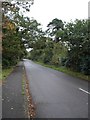
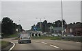
Lane with no name, St Leonards
Runs parallel to A31
Image: © Toby
Taken: 26 Oct 2006
0.05 miles
2
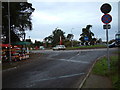
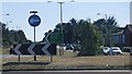
A31 roundabout, St. Leonards, Dorset
This is the access road to Avon Heath Country Park.
Image: © Stuart Buchan
Taken: 27 Nov 2005
0.05 miles
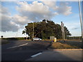
4
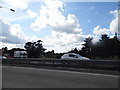
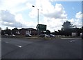
Roundabout on the A31 in St. Leonards
Seen from the car park of the Image
Image: © Andy Potter
Taken: 30 Jul 2011
0.07 miles
8
The Little Chef on the A31, St Leonards
Image: © David Howard
Taken: 3 Jul 2017
0.08 miles
9
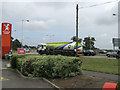
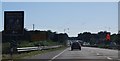
Brocks Pine Roundabout on the A31, St Leonards
Image: © David Howard
Taken: 3 Jul 2017
0.09 miles
10
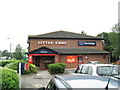
Little Chef and Travelodge
This is the smallest Little Chef I've ever visited.
Image: © Andy Potter
Taken: 30 Jul 2011
0.09 miles