IMAGES TAKEN NEAR TO
Birchwood Place, RINGWOOD, BH24 2DR
Introduction
This page details the photographs taken nearby to Birchwood Place, BH24 2DR by members of the Geograph project.
The Geograph project started in 2005 with the aim of publishing, organising and preserving representative images for every square kilometre of Great Britain, Ireland and the Isle of Man.

There are currently over 7.5m images from over14,400 individuals and you can help contribute to the project by visiting https://www.geograph.org.uk
Image Map (Loading...)


Getting Data...Please wait
Leaflet Map data © OpenStreetMap
Images are licensed for reuse under creativecommons.org/licenses/by-sa/2.0
Notes
- Clicking on the map will re-center to the selected point.
- The higher the marker number, the further away the image location is from the centre of the postcode.
Image Listing (6 Images Found)
Images are licensed for reuse under creativecommons.org/licenses/by-sa/2.0
Image
Details
Distance
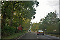
1
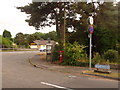
St. Leonards: postbox № BH24 24 and phone, Oaks Drive
This Elizabeth II-reign postbox and neighbouring telephone box stand on the corner of Oaks Drive and the busy A31 Ringwood Road. The postbox is emptied daily, except Sundays, at 9am.
Image: © Chris Downer
Taken: 8 Jun 2009
0.05 miles
2
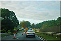
A31 lane closure
Southern Gas Networks were digging a hole.
Image: © Robin Webster
Taken: 30 Oct 2012
0.06 miles
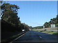
5
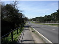
St. Leonards, A31
Dual carriageway from Ringwood to Wimborne.
Image: © Mike Faherty
Taken: 7 Apr 2011
0.15 miles
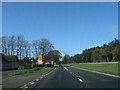
6
Westbound A31 - reduce speed now
There is already a 50 limit, but there is a roundabout ahead.
Image: © Robin Webster
Taken: 30 Oct 2012
0.20 miles