IMAGES TAKEN NEAR TO
Hampton Drive, RINGWOOD, BH24 1SL
Introduction
This page details the photographs taken nearby to Hampton Drive, BH24 1SL by members of the Geograph project.
The Geograph project started in 2005 with the aim of publishing, organising and preserving representative images for every square kilometre of Great Britain, Ireland and the Isle of Man.

There are currently over 7.5m images from over14,400 individuals and you can help contribute to the project by visiting https://www.geograph.org.uk
Image Map
Images are licensed for reuse under creativecommons.org/licenses/by-sa/2.0
Notes
- Clicking on the map will re-center to the selected point.
- The higher the marker number, the further away the image location is from the centre of the postcode.
Image Listing (6 Images Found)
Images are licensed for reuse under creativecommons.org/licenses/by-sa/2.0
Image
Details
Distance
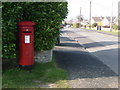
1
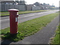
Ringwood: postbox № BH24 39, Hampton Drive
Looking along Hampton Drive from close to its junction with Seymour Road. The Elizabeth II-reign postbox is emptied finally at 5:15pm on weekdays and at noon on Saturdays.
Image: © Chris Downer
Taken: 20 Mar 2011
0.06 miles
4
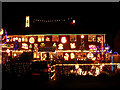
Christmas lights, Fairlie Park, Ringwood
Every year a number of residents in this part of Ringwood decorate their houses with an incredible array of festive lights. Money raised from visitors and passers by is donated to various local charities.
Image: © Jim Champion
Taken: 9 Dec 2005
0.17 miles
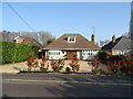
5
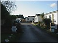
Ringwood, park homes
Lumby Drive Park, off Southampton Road.
Image: © Mike Faherty
Taken: 9 Jan 2011
0.22 miles
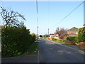
6
Ringwood: postbox № BH24 15, Southampton Road
This Elizabeth II-reign postbox stands on the corner of Fieldway, along which we are looking, and is emptied finally at 4pm on weekdays and at noon on Saturdays.
Image: © Chris Downer
Taken: 20 Mar 2011
0.24 miles