IMAGES TAKEN NEAR TO
Spittlefields, RINGWOOD, BH24 1QH
Introduction
This page details the photographs taken nearby to Spittlefields, BH24 1QH by members of the Geograph project.
The Geograph project started in 2005 with the aim of publishing, organising and preserving representative images for every square kilometre of Great Britain, Ireland and the Isle of Man.

There are currently over 7.5m images from over14,400 individuals and you can help contribute to the project by visiting https://www.geograph.org.uk
Image Map
Images are licensed for reuse under creativecommons.org/licenses/by-sa/2.0
Notes
- Clicking on the map will re-center to the selected point.
- The higher the marker number, the further away the image location is from the centre of the postcode.
Image Listing (15 Images Found)
Images are licensed for reuse under creativecommons.org/licenses/by-sa/2.0
Image
Details
Distance
3
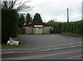
Ringwood, scout hut
Headquarters of the 3rd Ringwood Scout Group, on Eastfield Lane.
Image: © Mike Faherty
Taken: 8 Jan 2011
0.16 miles
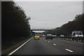
9
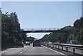
Footbridge over A31
The path connects residential areas of Ringwood.
Image: © Robin Webster
Taken: 30 Oct 2012
0.21 miles