IMAGES TAKEN NEAR TO
Southampton Road, RINGWOOD, BH24 1JE
Introduction
This page details the photographs taken nearby to Southampton Road, BH24 1JE by members of the Geograph project.
The Geograph project started in 2005 with the aim of publishing, organising and preserving representative images for every square kilometre of Great Britain, Ireland and the Isle of Man.

There are currently over 7.5m images from over14,400 individuals and you can help contribute to the project by visiting https://www.geograph.org.uk
Image Map
Images are licensed for reuse under creativecommons.org/licenses/by-sa/2.0
Notes
- Clicking on the map will re-center to the selected point.
- The higher the marker number, the further away the image location is from the centre of the postcode.
Image Listing (259 Images Found)
Images are licensed for reuse under creativecommons.org/licenses/by-sa/2.0
Image
Details
Distance
1
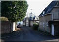
Ringwood, coach house
Former coach house in The Sweep, once serving the Manor House, opposite.
Image: © Mike Faherty
Taken: 9 Jan 2011
0.03 miles
3
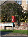
Ringwood: postbox № BH24 69, Southampton Road
This postbox stands on the corner of Linden Gardens and receives its final collection at 4pm on weekdays and at noon on Saturdays.
Image: © Chris Downer
Taken: 20 Mar 2011
0.05 miles
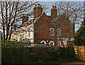
4
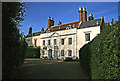
The Manor House - Ringwood
Once the residence of the Lord Chief Justice of England, William Murray (1705 - 1793), 1st Earl of Mansfield. The main building dates from the early C18, with the west wing (now a separate residence) dating from the late C18. Grade II* Listed.
Image: © Mike Searle
Taken: 25 Nov 2007
0.06 miles
5
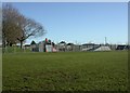
Ringwood, skate park
In Carvers Recreation Ground, off Southampton Road. http://www.ringwood.gov.uk/Leisure_and_Tourism/Youth/Content/Skate%20Park.html
Image: © Mike Faherty
Taken: 9 Jan 2011
0.07 miles
6
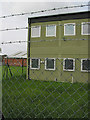
Ringwood Health Centre (detail)
This is not a concentration camp, rather it is Ringwood Health Centre which backs onto Carvers Recreation Ground. There is a skateboard park directly behind the photographer. As someone who lived in Ringwood as a child from 1951 to 1971, I was quite shocked by the extent to which a public building of this kind now has to be protected from vandals.
Image: © Peter Facey
Taken: 28 May 2006
0.07 miles
7
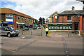
Southampton Road, Ringwood
Looking across Mansfield Road at part of Southampton Road. Southampton Road used to be the main road into the town and carried the A31. The bit seen ahead here is now a cul de sac, made after the Ringwood bypass was built. To the right of the yellow woman can be seen Austin & Wyatt, a long standing Ringwood estate agent.
Image: © Peter Facey
Taken: 23 May 2006
0.10 miles
8
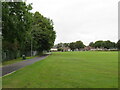
Recreation Ground, Ringwood
A recreation ground in the Hampshire town of Ringwood.
Image: © Malc McDonald
Taken: 20 Aug 2021
0.10 miles
10
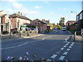
Ringwood : Mansfield Road
The junction on the right is to Southampton Road. There are some flower baskets located under where the photo is taken.
Image: © Lewis Clarke
Taken: 16 Oct 2009
0.11 miles