
IMAGES TAKEN NEAR TO
Market Place, RINGWOOD, BH24 1AP
Introduction
This page details the photographs taken nearby to Market Place, BH24 1AP by members of the Geograph project.
The Geograph project started in 2005 with the aim of publishing, organising and preserving representative images for every square kilometre of Great Britain, Ireland and the Isle of Man.

There are currently over 7.5m images from over14,400 individuals and you can help contribute to the project by visiting https://www.geograph.org.uk
Image Map
Images are licensed for reuse under creativecommons.org/licenses/by-sa/2.0
Notes
- Clicking on the map will re-center to the selected point.
- The higher the marker number, the further away the image location is from the centre of the postcode.
Image Listing (485 Images Found)
Images are licensed for reuse under creativecommons.org/licenses/by-sa/2.0
Image
Details
Distance
1
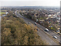
A31 road widening and bridge replacement 2020-22
Aerial. Looking from the new bridge (behind camera) northeast at the A31 as it bypass Ringwood (actually the A31 cuts Ringwood in two, the mainly residential area to the north of the road being somewhat isolated from the main town to the south, but that was a story from the 1960s). Church of St. Peter & St. Paul is prominent in this view. To its right is the market place.
Image: © Peter Facey
Taken: 2 Mar 2023
0.03 miles
2
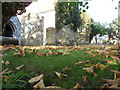
Ringwood : Church of St. Peter and St. Paul Churchyard
Leaves on the ground, and a lot of old gravestones to be covered by them.
Image: © Lewis Clarke
Taken: 16 Oct 2009
0.03 miles
3
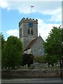
Church of St. Peter and St. Paul, Ringwood
The church is approached through an avenue of limes that were planted 200 years ago. It was rebuilt during the 19th century.
Image: © Stuart Buchan
Taken: 17 May 2005
0.03 miles
4
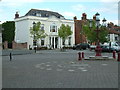
Market Place, Ringwood
Ringwood's Market Charter goes back to 1226 the time when Henry III granted Richard Marshal, who was then the Lord of the Manor the right to hold a Wednesday market.
In the photo can be seen the Millennium Sundial with the old Bank House in the background.
Image: © Stuart Buchan
Taken: 17 May 2005
0.03 miles
5
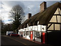
Ringwood: restaurant on West Street
An attractive row of thatched cottages in West Street has been in use as a restaurant for many years.
Image: © Chris Downer
Taken: 18 Dec 2011
0.03 miles
6
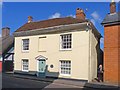
Monmouth House, Ringwood
Situated in West Street, this house became famous in 1685 when the Duke of Monmouth was imprisoned there after he had been captured, following his defeat at the Battle of Sedgemoor. This was the final chapter in an uprising which Monmouth led against the monarchy. He was eventually transferred to London where he was executed.
Image: © mike smith
Taken: 2 Apr 2013
0.03 miles
7
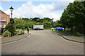
Market Place dead end, Ringwood
Ringwood High Street used to emerge here onto the A31, which is directly behind the greenery. The church is immediately off-picture right. This dead end was created at the northwestern end of the Market Place when the A31 was dualled and a grade-separated junction made where the A338 crosses the A31.
Image: © Peter Facey
Taken: 23 May 2006
0.03 miles
8
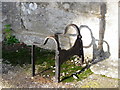
Boot scraper, Church of Sts Peter and Paul
One of the two boot scrapers at the door of the south porch.
These metal objects are prized by antique dealers, revered by history buffs, but are an object of puzzlement to many a 21st century pedestrian.
Image: © Maigheach-gheal
Taken: 19 Nov 2011
0.03 miles
9
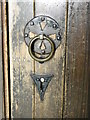
Detail, The Church of Sts Peter and Paul
This is the door furniture on the south door to the church.
Image: © Maigheach-gheal
Taken: 19 Nov 2011
0.03 miles
10
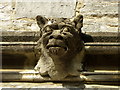
Grotesque, The Church of Sts Peter and Paul
Stone masons had free choice as to what their gargoyles and grotesques should depict or look like. It is an interesting fact that there is no two which are exactly the same!
Image: © Maigheach-gheal
Taken: 19 Nov 2011
0.03 miles