IMAGES TAKEN NEAR TO
Anna Lane, CHRISTCHURCH, BH23 8ER
Introduction
This page details the photographs taken nearby to Anna Lane, BH23 8ER by members of the Geograph project.
The Geograph project started in 2005 with the aim of publishing, organising and preserving representative images for every square kilometre of Great Britain, Ireland and the Isle of Man.

There are currently over 7.5m images from over14,400 individuals and you can help contribute to the project by visiting https://www.geograph.org.uk
Image Map (Loading...)


Getting Data...Please wait
Leaflet Map data © OpenStreetMap
Images are licensed for reuse under creativecommons.org/licenses/by-sa/2.0
Notes
- Clicking on the map will re-center to the selected point.
- The higher the marker number, the further away the image location is from the centre of the postcode.
Image Listing (19 Images Found)
Images are licensed for reuse under creativecommons.org/licenses/by-sa/2.0
Image
Details
Distance
1
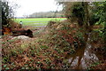
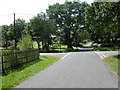
Small Stream on Anna Lane
This stream which runs under the minor road from the B3347 at Tyrell's Ford to North Ripley is the boundary of the New Forest national park with the park on the right and ordinary farm fields on the left.
Image: © Nigel Mykura
Taken: 6 Mar 2019
0.10 miles
2
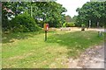
Green at North Ripley
This small green by the crossroads has a bench and a prominently-placed letter box.
Image: © mike smith
Taken: 22 Jul 2013
0.14 miles
3
Humped bridge between Ripley and North Ripley
A curious feature for what appears to be an ordinary drainage ditch or small stream. Old maps suggest there was once a ford - so perhaps the easiest way was to build up a bridge over.
Image: © Robin Webster
Taken: 6 Nov 2016
0.14 miles
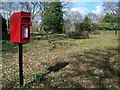
4
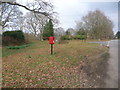
North Ripley: postbox № BH23 50
This small postbox is on a grassy spot by the crossroads, Anna Lane to the left and Bennetts Lane to the right. It is emptied at 9am daily, except Sundays, and it looks like you might be well advised to wear wellies if you wish to use it.
Image: © Chris Downer
Taken: 1 Mar 2009
0.14 miles
5
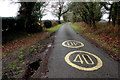
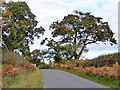
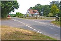
Anna Lane near Bail's Copse
This is the minor road from the B3347 at Tyrell's Ford to North Ripley showing the yellow speed limit reminder of 40mph for the New Forest painted on the road
Image: © Nigel Mykura
Taken: 6 Mar 2019
0.15 miles
6
Village green, Ripley
There is a small grassy area at the cross roads where there is a postbox and seat and spring flowers.
Image: © Maigheach-gheal
Taken: 2 Mar 2009
0.15 miles
7
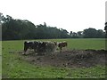
North Ripley, cattle feeder
Off Anna Lane.
Image: © Mike Faherty
Taken: 2 Sep 2010
0.15 miles
8
View from North Ripley
This view is seen looking south-east from the small village green.
Image: © mike smith
Taken: 22 Jul 2013
0.15 miles
9
Crossroads at North Ripley
The signpost near the house shows that the road ahead is for Ringwood, to the right is Bransgore, left for Avon, and behind the camera, the road leads to Sopley.
Image: © mike smith
Taken: 22 Jul 2013
0.16 miles
10
North Ripley, crossroads
To the left, Bennet's Lane; to the right, Anna Lane; straight ahead, to Ripley.
Image: © Mike Faherty
Taken: 30 Aug 2010
0.16 miles