IMAGES TAKEN NEAR TO
School Lane, CHRISTCHURCH, BH23 8DT
Introduction
This page details the photographs taken nearby to School Lane, BH23 8DT by members of the Geograph project.
The Geograph project started in 2005 with the aim of publishing, organising and preserving representative images for every square kilometre of Great Britain, Ireland and the Isle of Man.

There are currently over 7.5m images from over14,400 individuals and you can help contribute to the project by visiting https://www.geograph.org.uk
Image Map (Loading...)


Getting Data...Please wait
Leaflet Map data © OpenStreetMap
Images are licensed for reuse under creativecommons.org/licenses/by-sa/2.0
Notes
- Clicking on the map will re-center to the selected point.
- The higher the marker number, the further away the image location is from the centre of the postcode.
Image Listing (86 Images Found)
Images are licensed for reuse under creativecommons.org/licenses/by-sa/2.0
Image
Details
Distance
1
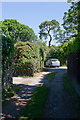
The closed end of School Lane, Thorney Hill
This narrow cul de sac affords access to private houses and runs north from School Road.
Image: © Peter Facey
Taken: 3 Jun 2010
0.02 miles
2
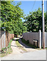
School Lane, Thorney Hill
A cul de sac running north from School Road and affording access to private houses.
Image: © Peter Facey
Taken: 3 Jun 2010
0.04 miles
3
The Forge, School Road, Thorney Hill
The Forge is the building with the green door on the left. I presume it still functions as such.
Image: © Peter Facey
Taken: 3 Jun 2010
0.04 miles
4
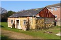
The Old Forge
This building, which appears to have been recently restored, was obviously the village forge in times gone by. It may now be a private dwelling.
Image: © mike smith
Taken: 1 Mar 2012
0.04 miles
5

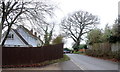
School Road, Thorney Hill, near Bransgore
School Road is a minor road in the hamlet of Thorney Hill, in the New Forest National Park.
This image was taken on a dull and murky day in late December. Deciduous trees were bare for the winter season.
Image: © Malc McDonald
Taken: 28 Dec 2024
0.05 miles
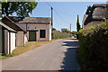
6
School Road.
School Rd is one of the older roads of Thorney Hill. It cuts the corner between the Burley rd and Forest Rd.
Image: © Nigel Mykura
Taken: 6 Mar 2019
0.07 miles
7

Forest Edge, Thorney Hill, near Bransgore
Forest Edge is an unmade road in the hamlet of Thorney Hill, in the New Forest National Park.
This image was taken in December 2024, after a prolonged wet spell. The road was muddy as a result.
Image: © Malc McDonald
Taken: 28 Dec 2024
0.07 miles
9

School Road, Thorney Hill, near Bransgore
School Road is a minor lane in the hamlet of Thorney Hill, in the New Forest National Park.
This image was taken on a dull and murky day in late December. Deciduous trees were bare for the winter season.
Image: © Malc McDonald
Taken: 28 Dec 2024
0.08 miles
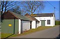
10
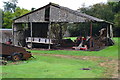
Rustic Shed
Looking as if its finer days are long gone, this shed is right next to the back gardens of some modern homes.
Image: © mike smith
Taken: 1 Mar 2012
0.08 miles