IMAGES TAKEN NEAR TO
Stony Lane, CHRISTCHURCH, BH23 7LQ
Introduction
This page details the photographs taken nearby to Stony Lane, BH23 7LQ by members of the Geograph project.
The Geograph project started in 2005 with the aim of publishing, organising and preserving representative images for every square kilometre of Great Britain, Ireland and the Isle of Man.

There are currently over 7.5m images from over14,400 individuals and you can help contribute to the project by visiting https://www.geograph.org.uk
Image Map
Images are licensed for reuse under creativecommons.org/licenses/by-sa/2.0
Notes
- Clicking on the map will re-center to the selected point.
- The higher the marker number, the further away the image location is from the centre of the postcode.
Image Listing (53 Images Found)
Images are licensed for reuse under creativecommons.org/licenses/by-sa/2.0
Image
Details
Distance
1
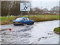
Flooded Stoney Lane
Following near-constant rain in January 2014, there was much flooding in the Christchurch area. This is Stoney Lane by the entrance to B&Q and Currys/PC World. The water was at least 30cm (1 foot) deep in the centre. The car is heading to Stoney Lane roundabout.
Image: © mike smith
Taken: 8 Jan 2014
0.05 miles
2
Flooded Stoney Lane
Following near-constant rain in January 2014, there was much flooding in the Christchurch area. This is Stoney Lane by the entrance to B&Q and Currys/PC World. The water was at least 30 cm (1 foot) deep in the centre.
Image: © mike smith
Taken: 8 Jan 2014
0.05 miles
3
Retail Park, Purewell
This is one of the many retail parks in the area.
Image: © Stuart Buchan
Taken: 4 Nov 2005
0.06 miles
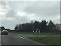
4
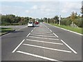
Purewell Cross Road
This road was constructed in the 1980s to provide access to the Christchurch Bypass from Purewell, Stanpit and Mudeford.
Image: © mike smith
Taken: 21 Oct 2007
0.07 miles
5
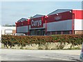
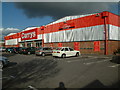
Stony Lane Retail Park
This park contains Currys, B&Q, and a couple of smaller outlets.
Image: © mike smith
Taken: 21 Oct 2007
0.08 miles
6
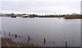
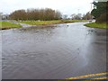
Flood Waters at Purewell Meadows
Although a winter flood plain, in summer this is a meadow with horses grazing. After days of near-constant rain in January 2014, the local rivers are in flood. This water is from the River Avon. The commercial buildings in the background are in Stoney Lane, and when the photo was taken, were not flooded.
Image: © mike smith
Taken: 8 Jan 2014
0.09 miles
9

Harlem Mews
This short terrace of modern houses is on a small modern estate in Purewell. It is just off Rotterdam Close, which is just off Scotts Hills lane which itself is just off Purwell Cross Road.
Image: © Nigel Mykura
Taken: 9 Feb 2019
0.12 miles
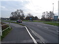
10

Honda Dealership at Purewell
This complex was opened in 2006, on Stony Lane, Purewell.
Image: © mike smith
Taken: 21 Oct 2007
0.12 miles