IMAGES TAKEN NEAR TO
Mallow Close, CHRISTCHURCH, BH23 4UL
Introduction
This page details the photographs taken nearby to Mallow Close, BH23 4UL by members of the Geograph project.
The Geograph project started in 2005 with the aim of publishing, organising and preserving representative images for every square kilometre of Great Britain, Ireland and the Isle of Man.

There are currently over 7.5m images from over14,400 individuals and you can help contribute to the project by visiting https://www.geograph.org.uk
Image Map (Loading...)


Getting Data...Please wait
Leaflet Map data © OpenStreetMap
Images are licensed for reuse under creativecommons.org/licenses/by-sa/2.0
Notes
- Clicking on the map will re-center to the selected point.
- The higher the marker number, the further away the image location is from the centre of the postcode.
Image Listing (12 Images Found)
Images are licensed for reuse under creativecommons.org/licenses/by-sa/2.0
Image
Details
Distance
1
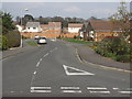
Housing off Hoburne Lane
Built on the land of the original Hoburne Farm.
Image: © mike smith
Taken: 25 Mar 2007
0.06 miles
2
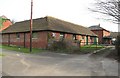
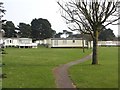
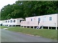
Hoburne Farm Buildings
Only the farm yard buildings remain from the original farm. The rest is now a caravan park and an extensive housing development (see other pictures in this square).
Image: © mike smith
Taken: 25 Mar 2007
0.10 miles
4
Christchurch: postbox № BH23 65, Hoburne Lane
A small postbox emptied finally at 5:15pm on weekdays and at noon on Saturdays.
Image: © Chris Downer
Taken: 9 Aug 2009
0.14 miles
5
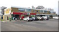
Saulflands Shops
Just round the corner from Saulflands House is this row of shops, comprising the Spar grocery store, a pet shop and a hair dressers.
Image: © mike smith
Taken: 25 Mar 2007
0.15 miles
8
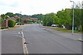
Saffron Drive, Hoburne Estate
This massive housing estate is built on the former Hoburne Farm.
Image: © mike smith
Taken: 3 Jul 2010
0.20 miles
9
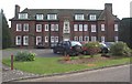
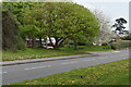
Saulflands House
Built as a mansion just before World War I, it was used by the A.T.S. during World War II. After the war it was divided into 10 flats, which are still in use.
Image: © mike smith
Taken: 25 Mar 2007
0.20 miles
10
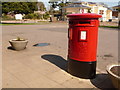
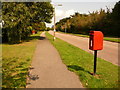
Highcliffe: postbox № BH23 96, Saulfland Place
This postbox stands outside the Saulflands Post Office (see Image) and is emptied finally at 5:30pm on weekdays and at 12:30pm on Saturdays.
Image: © Chris Downer
Taken: 13 Apr 2009
0.21 miles