IMAGES TAKEN NEAR TO
Harriers Close, CHRISTCHURCH, BH23 4SL
Introduction
This page details the photographs taken nearby to Harriers Close, BH23 4SL by members of the Geograph project.
The Geograph project started in 2005 with the aim of publishing, organising and preserving representative images for every square kilometre of Great Britain, Ireland and the Isle of Man.

There are currently over 7.5m images from over14,400 individuals and you can help contribute to the project by visiting https://www.geograph.org.uk
Image Map (Loading...)


Getting Data...Please wait
Leaflet Map data © OpenStreetMap
Images are licensed for reuse under creativecommons.org/licenses/by-sa/2.0
Notes
- Clicking on the map will re-center to the selected point.
- The higher the marker number, the further away the image location is from the centre of the postcode.
Image Listing (53 Images Found)
Images are licensed for reuse under creativecommons.org/licenses/by-sa/2.0
Image
Details
Distance
1
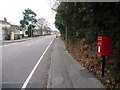
Highcliffe: postbox № BH23 72, Smugglers Lane North
A small box at the terminus of Smugglers Lane North (ahead), Smugglers Lane South (to the left) and Moonrakers Way (behind camera). The box is emptied finally at 5:30pm on weekdays and at 12:30pm on Saturdays.
Image: © Chris Downer
Taken: 31 Jan 2009
0.03 miles
2
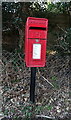
Elizabeth II postbox on Smugglers Lane North
Postbox No. BH23 72.
Image: © JThomas
Taken: 22 Mar 2022
0.04 miles
3
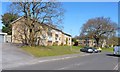
Terraced Homes on Rowan Drive
This is a part of Highcliffe in Dorset, which has a huge residential area.
Image: © mike smith
Taken: 1 Apr 2012
0.06 miles
4
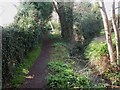
Highcliffe, footpath
Footpath from Smugglers' Lane to Barnfield, alongside Image, also seen to the right here; very rural in character, despite being in suburbia.
Image: © Mike Faherty
Taken: 20 Mar 2009
0.07 miles
5
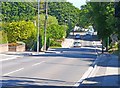
Smugglers Lane North, Highcliffe, Dorset
This road runs more or less parallel to the A337 Lymington Road, and it therefore busy with vehicles avoiding the major traffic route.
Image: © mike smith
Taken: 31 Aug 2013
0.08 miles
6
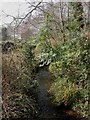
Highcliffe, Bure Brook
Just West of Smugglers' Lane & Image, the brook flows South-West to enter Christchurch Harbour. Easy to think you're in the country, rather than (very pleasant) suburbia.
Image: © Mike Faherty
Taken: 20 Mar 2009
0.08 miles
7
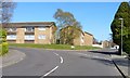
Rowan Drive Road Junction
This is in Highcliffe, Dorset. All three roads from this junction are called Rowan Drive.
Image: © mike smith
Taken: 1 Apr 2012
0.10 miles
8
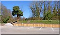
New Bank Retaining Wall at Nea Meadow
Nea Meadow is in Highcliffe, Dorset, and is a small nature reserve. In March 2012 a new bank retaining wall was installed, comprising steel piles with a hard wood facing.
Image: © mike smith
Taken: 1 Apr 2012
0.12 miles
9
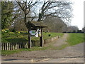
Nea Meadows Nature Reserve
Information board near the Smugglers' Lane entrance. According to the board, the reserve was originally park & grassland belonging to now-demolished Nea House, bought by Christchurch Council in 1960 & created nature reserve in 2005.http://www.dorsetforyou.com/index.jsp?articleid=386518
Image: © Mike Faherty
Taken: 20 Mar 2009
0.13 miles
10
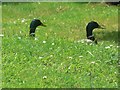
Highcliffe: two ducks? heads
These two mallards are stood on a sloping piece of grass alongside Image
Image: © Chris Downer
Taken: 31 May 2008
0.14 miles