IMAGES TAKEN NEAR TO
Freshwater Road, CHRISTCHURCH, BH23 4PD
Introduction
This page details the photographs taken nearby to Freshwater Road, BH23 4PD by members of the Geograph project.
The Geograph project started in 2005 with the aim of publishing, organising and preserving representative images for every square kilometre of Great Britain, Ireland and the Isle of Man.

There are currently over 7.5m images from over14,400 individuals and you can help contribute to the project by visiting https://www.geograph.org.uk
Image Map (Loading...)


Getting Data...Please wait
Leaflet Map data © OpenStreetMap
Images are licensed for reuse under creativecommons.org/licenses/by-sa/2.0
Notes
- Clicking on the map will re-center to the selected point.
- The higher the marker number, the further away the image location is from the centre of the postcode.
Image Listing (67 Images Found)
Images are licensed for reuse under creativecommons.org/licenses/by-sa/2.0
Image
Details
Distance
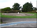
1

Maritime & Coastguard Agency (MCA)
This is one of the MCA's training centre buildings, on the same complex.
Image: © mike smith
Taken: 22 Jul 2007
0.09 miles
3
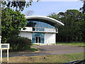
The Billy Deacon Building, Highcliffe
This modern building is part of the Maritime and Coastguard Agency's Training Centre at Highcliffe, and contains an operations room simulator and classrooms. It was named after Billy Deacon, a Coastguard helicopter winchman who tragically lost his life during the rescue of the crew of the Green Lily on the Scottish coast in 1997.
Image: © Stephen Williams
Taken: 13 Jun 2007
0.10 miles
4
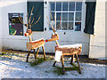
Reindeer at Steamer Point
These wooden reindeer were made by a wood sculptor who often works in the adjacent Steamer Point Nature Reserve.
Image: © mike smith
Taken: 18 Dec 2010
0.11 miles
5
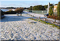
Concrete Base, Skynet Radome
This concrete base close to the seafront at Friarsclif east of Christchurch once supported a large radome which was part of the UK's first aerial defence system known as Skynet.
Image: © Nigel Mykura
Taken: 31 Oct 2009
0.11 miles
6
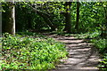
Pathway at Steamer Point
This view, towards Friars Cliff, is taken close to the Steamer Point Information Centre.
Image: © mike smith
Taken: 18 Dec 2010
0.11 miles
7
Cliff training wall at Highcliffe
This concrete cliff is used in Coastguard training at the MCA Training Centre at Highcliffe.
Image: © Stephen Williams
Taken: 13 Jun 2007
0.11 miles
8
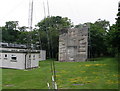
Old radar site at Highcliffe
This large concrete circle, and the two smaller ones behind were the bases of large radar domes used for post-war research and development. The story of the site is told on a plaque on the monument in the centre of the circle.
Image: © Stephen Williams
Taken: 13 Jun 2007
0.12 miles
9
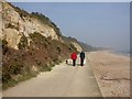
Friar's Cliff, cliffs
Most of the cliffs between Friar's Cliff & Highcliffe have been invaded by scrub, or planted with trees to combat erosion. 250m remain, of Eocene Boscombe Sands & Barton Clay. Miner bees are much in evidence, flying in & out of holes in the sands in the cliffs. For a full description of local geology, see http://www.soton.ac.uk/~imw/barton.htm
Image: © Mike Faherty
Taken: 18 Mar 2009
0.12 miles
10
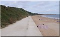
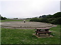
These don't come cheap
You need to look at a map to understand why the sea wall has been built here.
Image: © Fernweh
Taken: 9 Aug 2014
0.12 miles