IMAGES TAKEN NEAR TO
Grange Road, CHRISTCHURCH, BH23 4JD
Introduction
This page details the photographs taken nearby to Grange Road, BH23 4JD by members of the Geograph project.
The Geograph project started in 2005 with the aim of publishing, organising and preserving representative images for every square kilometre of Great Britain, Ireland and the Isle of Man.

There are currently over 7.5m images from over14,400 individuals and you can help contribute to the project by visiting https://www.geograph.org.uk
Image Map (Loading...)


Getting Data...Please wait
Leaflet Map data © OpenStreetMap
Images are licensed for reuse under creativecommons.org/licenses/by-sa/2.0
Notes
- Clicking on the map will re-center to the selected point.
- The higher the marker number, the further away the image location is from the centre of the postcode.
Image Listing (31 Images Found)
Images are licensed for reuse under creativecommons.org/licenses/by-sa/2.0
Image
Details
Distance
1
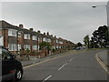
Grange Road, Christchurch
More housing on the former Christchurch airfield site.
Image: © Peter Beaven
Taken: 26 Apr 2007
0.02 miles
2
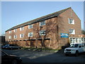
Christchurch Business Centre
Christchurch Business Centre in Grange Road
Image: © Peter Beaven
Taken: 14 Mar 2007
0.07 miles
3
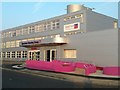
Spectrum Housing Group
The new reception entrance completed in February 2012.
Image: © Peter Beaven
Taken: 1 Mar 2012
0.10 miles
4
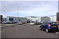
Airspeed Road
This is the priory Industrial Estate and the names of its roads are all to do with aircraft. Airspeed road is off Runway Rd and is next to Brabazon Rd.
Image: © Nigel Mykura
Taken: 6 Mar 2019
0.12 miles
5
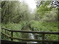
Mudeford Woods
The River Mude, looking upstream.
Image: © Peter Beaven
Taken: 26 Apr 2007
0.13 miles
6
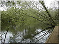
Angling lake, Mudeford Woods
Looking across the northernmost of the lakes.
Image: © Peter Beaven
Taken: 26 Apr 2007
0.15 miles
7
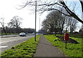
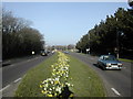
Highcliffe Road (A337)
See https://www.geograph.org.uk/photo/7318293 for postbox.
Showing position of Postbox No. BH23 105.
Image: © JThomas
Taken: 22 Mar 2022
0.18 miles
8
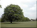
Horse chestnut
This magnificent tree stands just beyond the boundary of the East Christchurch Cricket Club's pitch between Grange Road, Highcliffe Road and Mudeford Woods.
Image: © Peter Beaven
Taken: 26 Apr 2007
0.18 miles
9
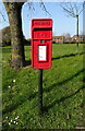
Elizabeth II postbox on Highcliffe Road (A337)
See https://www.geograph.org.uk/photo/7318291 for context.
Postbox No. BH23 105.
Image: © JThomas
Taken: 22 Mar 2022
0.19 miles
10
Highcliffe Road, Christchurch
The A337 Highcliffe Road alongside BAE Systems (formerly SRDE, Plesseys and British Aerospace).
Image: © Peter Beaven
Taken: 14 Mar 2007
0.19 miles