IMAGES TAKEN NEAR TO
Seaway Avenue, CHRISTCHURCH, BH23 4AU
Introduction
This page details the photographs taken nearby to Seaway Avenue, BH23 4AU by members of the Geograph project.
The Geograph project started in 2005 with the aim of publishing, organising and preserving representative images for every square kilometre of Great Britain, Ireland and the Isle of Man.

There are currently over 7.5m images from over14,400 individuals and you can help contribute to the project by visiting https://www.geograph.org.uk
Image Map
Images are licensed for reuse under creativecommons.org/licenses/by-sa/2.0
Notes
- Clicking on the map will re-center to the selected point.
- The higher the marker number, the further away the image location is from the centre of the postcode.
Image Listing (124 Images Found)
Images are licensed for reuse under creativecommons.org/licenses/by-sa/2.0
Image
Details
Distance
7
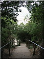
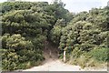
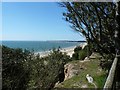
Steps to the beach at Highcliffe
These steps lead down from the Steamer Point Nature Reserve to the beach at Highcliffe.
Image: © Stephen Williams
Taken: 13 Jun 2007
0.04 miles
8
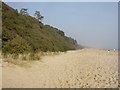
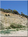
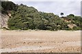
Highcliffe, trees on cliff
Evergreen oaks originally planted in the C19 to stabilise the cliffs; now self-seeding.
Image: © Mike Faherty
Taken: 18 Mar 2009
0.04 miles