IMAGES TAKEN NEAR TO
Farm Lane, CHRISTCHURCH, BH23 4AH
Introduction
This page details the photographs taken nearby to Farm Lane, BH23 4AH by members of the Geograph project.
The Geograph project started in 2005 with the aim of publishing, organising and preserving representative images for every square kilometre of Great Britain, Ireland and the Isle of Man.

There are currently over 7.5m images from over14,400 individuals and you can help contribute to the project by visiting https://www.geograph.org.uk
Image Map (Loading...)


Getting Data...Please wait
Leaflet Map data © OpenStreetMap
Images are licensed for reuse under creativecommons.org/licenses/by-sa/2.0
Notes
- Clicking on the map will re-center to the selected point.
- The higher the marker number, the further away the image location is from the centre of the postcode.
Image Listing (90 Images Found)
Images are licensed for reuse under creativecommons.org/licenses/by-sa/2.0
Image
Details
Distance
1
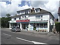
Local Shops at Mudeford
These shops provide local residents with the essentials of life.
Image: © mike smith
Taken: 18 Jul 2007
0.05 miles

3
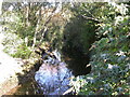
River Mude at Mudeford
Facing north from the road bridge, just north of its mouth into Christchurch Harbour; here, the river forms a boundary between different gardens. No raging torrent.
Image: © Mike Faherty
Taken: 29 Oct 2008
0.07 miles
4
Mouth of River Mude
For its last few metres, the River Mude is channelled between concrete walls before it flows into Christchurch Harbour; on either side are gardens. Picture taken from road bridge at Mudeford.
Image: © Mike Faherty
Taken: 29 Oct 2008
0.07 miles
5
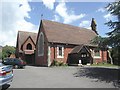
All Saints Parish Church
This small church was built in 1869, although has been extended a couple of times since. For a view of the inside, see Image
Image: © mike smith
Taken: 18 Jul 2007
0.09 miles
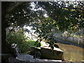
6
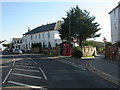
Victorian postbox at Mudeford
Penfold-type Victorian postbox. A good group of objects, with phone box, bus stop, road junction and signs.
Image: © Mike Faherty
Taken: 29 Oct 2008
0.09 miles
7
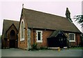
All Saints, Mudeford
Listed building erected in 1871.
Image: © Michael FORD
Taken: Unknown
0.09 miles
8

The Parish Church of All Saints, Mudeford
Image: © David Dixon
Taken: 4 Aug 2010
0.09 miles
9

The Parish Church of All Saints, Mudeford
Image: © David Dixon
Taken: 4 Aug 2010
0.09 miles
10
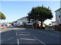
Mudeford
See https://www.geograph.org.uk/photo/7318251 for postbox
Showing position of Postbox No. BH23 5.
Image: © JThomas
Taken: 22 Mar 2022
0.09 miles