IMAGES TAKEN NEAR TO
Elderberry Lane, CHRISTCHURCH, BH23 3RW
Introduction
This page details the photographs taken nearby to Elderberry Lane, BH23 3RW by members of the Geograph project.
The Geograph project started in 2005 with the aim of publishing, organising and preserving representative images for every square kilometre of Great Britain, Ireland and the Isle of Man.

There are currently over 7.5m images from over14,400 individuals and you can help contribute to the project by visiting https://www.geograph.org.uk
Image Map (Loading...)


Getting Data...Please wait
Leaflet Map data © OpenStreetMap
Images are licensed for reuse under creativecommons.org/licenses/by-sa/2.0
Notes
- Clicking on the map will re-center to the selected point.
- The higher the marker number, the further away the image location is from the centre of the postcode.
Image Listing (14 Images Found)
Images are licensed for reuse under creativecommons.org/licenses/by-sa/2.0
Image
Details
Distance
1
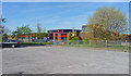
Mudeford Junior School
As can be seen, this is a modern building, situated in Mudeford Lane, and serving a large residential area.
Image: © mike smith
Taken: 9 Apr 2011
0.09 miles
2
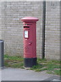
Christchurch: postbox № BH23 59, Mudeford Lane
This George VI-reign postbox is emptied finally at 5:30pm on weekdays and at 12:30pm on Saturdays.
Image: © Chris Downer
Taken: 29 Jun 2011
0.11 miles
3
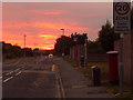
Christchurch: Mudeford Lane under an orange sky
Looking northwest along Mudeford Lane beneath the lovely orange sky that ended the evening. On the right is Image
Image: © Chris Downer
Taken: 30 Jun 2009
0.11 miles
4
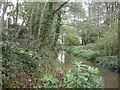
Mude Valley Nature Reserve
A grassland, woodland & river nature reserve owned by Christchurch Council. Trees are alder, oak, birch, ash & rhododendron; the last does not seem to have become invasive.
Image: © Mike Faherty
Taken: 2 Nov 2008
0.15 miles
5
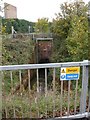
River Mude culverted
For most of its length, the River Mude can be walked along, apart from a culverted section about 200m long. Here, it is emerging from the culvert at the road bridge on De Havilland Way.
Image: © Mike Faherty
Taken: 2 Nov 2008
0.19 miles
6
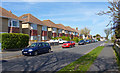
Stroud Road, Stanpit
Typical 'tween war housing on the north side of this road.
Image: © mike smith
Taken: 9 Apr 2011
0.23 miles
7
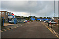
Airfield Road
Industrial Estate off Somerford Road.
Image: © David Lally
Taken: 3 Oct 2012
0.23 miles
8
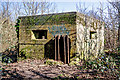
WWII defences in the environs of Bournemouth & Christchurch: Mudeford Wood, Christchurch - pillbox (1)
-
Pillbox (type FW3/22): DoB ID: e29835
Type 22 pillbox in Mudeford Wood, part of the wartime defences that protected the former Airspeed aircraft factory and the airfield of RAF Christchurch. It is the standard type, hexagonal in plan, with embrasures on all six sides including that of the entrance which has been blocked up with rails.
Image
Image: © Mike Searle
Taken: 15 Mar 2016
0.24 miles
9
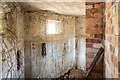
WWII defences in the environs of Bournemouth & Christchurch: Mudeford Wood, Christchurch - pillbox (2)
-
Pillbox (type FW3/22): DoB ID: e29835
Type 22 pillbox in Mudeford Wood, part of the wartime defences that protected the former Airspeed aircraft factory and the airfield of RAF Christchurch. The first of two interior views, this to the left looking in through one of the embrasures showing the concrete shuttered walls and ceiling, the outline of the wooden planks that were used being clearly visible. A 'T' or 'Y' shape anti-ricochet wall of brick divides the interior space in two. Battens under the embrasures are evidence that there were shelves underneath for the riflemen to rest their elbows and for their ammunition. There is an embrasure sized concrete block on the floor that may have been used to block off a loop that was not being used.
Image
Image: © Mike Searle
Taken: 15 Mar 2016
0.24 miles
10
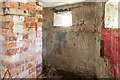
WWII defences in the environs of Bournemouth & Christchurch: Mudeford Wood, Christchurch - pillbox (3)
-
Pillbox (type FW3/22): DoB ID: e29835
Type 22 pillbox in Mudeford Wood, part of the wartime defences that protected the former Airspeed aircraft factory and the airfield of RAF Christchurch. The second interior view, this is to the right of the anti-ricochet wall.
Image
Image: © Mike Searle
Taken: 15 Mar 2016
0.24 miles