IMAGES TAKEN NEAR TO
Elderberry Lane, CHRISTCHURCH, BH23 3RN
Introduction
This page details the photographs taken nearby to Elderberry Lane, BH23 3RN by members of the Geograph project.
The Geograph project started in 2005 with the aim of publishing, organising and preserving representative images for every square kilometre of Great Britain, Ireland and the Isle of Man.

There are currently over 7.5m images from over14,400 individuals and you can help contribute to the project by visiting https://www.geograph.org.uk
Image Map (Loading...)


Getting Data...Please wait
Leaflet Map data © OpenStreetMap
Images are licensed for reuse under creativecommons.org/licenses/by-sa/2.0
Notes
- Clicking on the map will re-center to the selected point.
- The higher the marker number, the further away the image location is from the centre of the postcode.
Image Listing (11 Images Found)
Images are licensed for reuse under creativecommons.org/licenses/by-sa/2.0
Image
Details
Distance
1
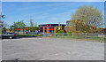
Mudeford Junior School
As can be seen, this is a modern building, situated in Mudeford Lane, and serving a large residential area.
Image: © mike smith
Taken: 9 Apr 2011
0.09 miles
2
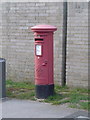
Christchurch: postbox № BH23 59, Mudeford Lane
This George VI-reign postbox is emptied finally at 5:30pm on weekdays and at 12:30pm on Saturdays.
Image: © Chris Downer
Taken: 29 Jun 2011
0.14 miles
3

Christchurch: Mudeford Lane under an orange sky
Looking northwest along Mudeford Lane beneath the lovely orange sky that ended the evening. On the right is Image
Image: © Chris Downer
Taken: 30 Jun 2009
0.15 miles
4
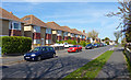
Stroud Road, Stanpit
Typical 'tween war housing on the north side of this road.
Image: © mike smith
Taken: 9 Apr 2011
0.17 miles
5
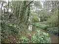
Mude Valley Nature Reserve
A grassland, woodland & river nature reserve owned by Christchurch Council. Trees are alder, oak, birch, ash & rhododendron; the last does not seem to have become invasive.
Image: © Mike Faherty
Taken: 2 Nov 2008
0.19 miles
6
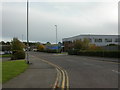
Airfield Way, Christchurch
Typical strictly functional industrial estate, built on an airfield site sold off in 1962. Will future industrial archaeologists take delight in sites like this as we do with our Georgian/Victorian industrial heritage?
Image: © Mike Faherty
Taken: 27 Oct 2008
0.22 miles
7
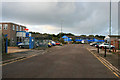
Airfield Road
Industrial Estate off Somerford Road.
Image: © David Lally
Taken: 3 Oct 2012
0.24 miles
8

Mudeford Lane
This is at the northern (Purewell) end of the lane.
Image: © mike smith
Taken: 9 Apr 2011
0.24 miles
9
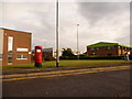
Somerford: postbox № BH23 508, Airfield Way
This modern postbox serves a modest industrial estate on the site of the former Somerford airfield – hence the name Airfield Way, along with nearby Airspeed Road, de Havilland Way and The Runway.
Items need to be in the box by 6 o'clock on weekday evenings, or noon on Saturdays, to be sure of catching the same day's post.
Image: © Chris Downer
Taken: 14 Jul 2009
0.24 miles
10
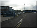
Airfield Way, Christchurch
Would a time-warp pilot be able to find the runway? The airfield, previously used by MoD, Airspeed/de Havilland and a flying club, closed in 1962, and the land was sold for redevelopment as housing and industrial estates.
Image: © Mike Faherty
Taken: 27 Oct 2008
0.24 miles