IMAGES TAKEN NEAR TO
Somerford Road, CHRISTCHURCH, BH23 3PL
Introduction
This page details the photographs taken nearby to Somerford Road, BH23 3PL by members of the Geograph project.
The Geograph project started in 2005 with the aim of publishing, organising and preserving representative images for every square kilometre of Great Britain, Ireland and the Isle of Man.

There are currently over 7.5m images from over14,400 individuals and you can help contribute to the project by visiting https://www.geograph.org.uk
Image Map
Images are licensed for reuse under creativecommons.org/licenses/by-sa/2.0
Notes
- Clicking on the map will re-center to the selected point.
- The higher the marker number, the further away the image location is from the centre of the postcode.
Image Listing (21 Images Found)
Images are licensed for reuse under creativecommons.org/licenses/by-sa/2.0
Image
Details
Distance
1
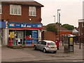
Christchurch: Purewell Cross Post Office and postbox № BH23 10
The corner shop of a line of three. The postbox is a modern one, emptied finally at 5:30pm on weekdays and at 12:30pm on Saturdays.
Image: © Chris Downer
Taken: 30 Jun 2009
0.04 miles
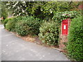
2
Christchurch: postbox № BH23 401, Court Close
Court Close is unusual for a little cul-de-sac, in having its very own postbox at the dead end – perhaps installed specifically for Purewell Court, in front of which it stands. The number of the postbox – 401 – maybe suggests a relatively recent addition to the network. The box is emptied at 9 o'clock each morning except Sunday – far earlier than any other box in the area.
Image: © Chris Downer
Taken: 30 Jun 2009
0.11 miles
3
Christchurch: postbox № BH23 66, Bingham Road
This George V-reign postbox, set into a brick pillar, is emptied finally at 5pm on weekdays and at noon on Saturdays.
Image: © Chris Downer
Taken: 30 Jun 2009
0.12 miles
4

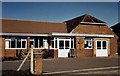
Mudeford Lane Methodist Church
This small red brick building which would look more at home on an industrial estate is at the south western end of Mudeford Lane.
Image: © Nigel Mykura
Taken: 9 Feb 2019
0.15 miles
5

Mudeford Lane
This is at the northern (Purewell) end of the lane.
Image: © mike smith
Taken: 9 Apr 2011
0.15 miles
7
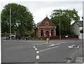
Purewell, mission church
Mission Church of St. John, at Purewell Roundabout; the foundation stone is dated 1880. http://christchurchpriory.org/stjohns.html
Image: © Mike Faherty
Taken: 10 Jun 2010
0.16 miles
8
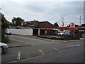
Yangs Chinese takeaway
Dennistoun Avenue off Somerford Road.
Image: © Anthony Vosper
Taken: 8 Aug 2012
0.17 miles
9
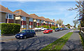
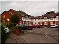
Stroud Road, Stanpit
Typical 'tween war housing on the north side of this road.
Image: © mike smith
Taken: 9 Apr 2011
0.18 miles
10
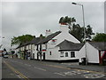
Purewell, Rising Sun
Pub and Thai restaurant on Purewell. Internally, L-shaped bar, with drinking areas on three sides, Mr. Poon's restaurant to the back, patio & garden. Cask ales on offer at my visit: Ringwood Best, Fortyniner. For some customer comments, see http://www.beerintheevening.com/pubs/s/26/2690/Rising_Sun/Christchurch
Image: © Mike Faherty
Taken: 10 Jun 2010
0.19 miles