IMAGES TAKEN NEAR TO
Coastguard Way, CHRISTCHURCH, BH23 3NR
Introduction
This page details the photographs taken nearby to Coastguard Way, BH23 3NR by members of the Geograph project.
The Geograph project started in 2005 with the aim of publishing, organising and preserving representative images for every square kilometre of Great Britain, Ireland and the Isle of Man.

There are currently over 7.5m images from over14,400 individuals and you can help contribute to the project by visiting https://www.geograph.org.uk
Image Map (Loading...)


Getting Data...Please wait
Leaflet Map data © OpenStreetMap
Images are licensed for reuse under creativecommons.org/licenses/by-sa/2.0
Notes
- Clicking on the map will re-center to the selected point.
- The higher the marker number, the further away the image location is from the centre of the postcode.
Image Listing (54 Images Found)
Images are licensed for reuse under creativecommons.org/licenses/by-sa/2.0
Image
Details
Distance
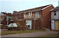
2
Foreshore at Fishermans Bank, Stanpit
Image: © David Gearing
Taken: 28 Feb 2011
0.04 miles
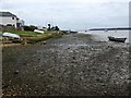
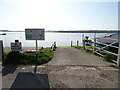
3
Mudeford, slipway
Public slipway on Fisherman's Bank, with Stanpit Marsh behind the water.
Image: © Mike Faherty
Taken: 24 Aug 2009
0.05 miles
4
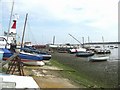
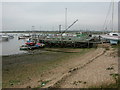
Boat Yard
This yard is on Fishermans Bank, overlooking Christchurch Harbour.
Image: © mike smith
Taken: 13 Jul 2007
0.05 miles
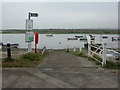
5
Mudeford Sailing Club
On Fisherman's Bank; the club's headquarters are the barge. Stanpit Marsh in the distance. http://www.mudefordsc.org/
Image: © Mike Faherty
Taken: 24 Aug 2009
0.05 miles
7
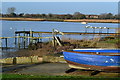
Blue boat and jetties on Stanpit shore
Image: © David Martin
Taken: 17 Dec 2018
0.06 miles
8
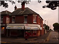
Christchurch: former Stanpit Post Office
Stanpit Post Office existed from 1 February 1895 until 20 March 2003; the shop did likewise a couple of years later.
See Image for a close-up of the George VI-reign postbox.
Image: © Chris Downer
Taken: 30 Jun 2009
0.06 miles
9
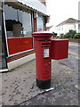
Christchurch: postbox № BH23 36, Stanpit
This George VI-reign postbox stands in the road named Stanpit, in the suburb of the same name. The building behind it is the former post office - see Image The box is emptied finally at 5:30pm on weekdays and at 12:15pm on Saturdays.
Image: © Chris Downer
Taken: 25 Dec 2011
0.06 miles
10

General Stores, Stanpit
See https://www.geograph.org.uk/photo/7318265 for postbox.
Showing position of Postbox No. BH23 36.
Image: © JThomas
Taken: 22 Mar 2022
0.06 miles