IMAGES TAKEN NEAR TO
St. Marys Close, CHRISTCHURCH, BH23 3FH
Introduction
This page details the photographs taken nearby to St. Marys Close, BH23 3FH by members of the Geograph project.
The Geograph project started in 2005 with the aim of publishing, organising and preserving representative images for every square kilometre of Great Britain, Ireland and the Isle of Man.

There are currently over 7.5m images from over14,400 individuals and you can help contribute to the project by visiting https://www.geograph.org.uk
Image Map (Loading...)


Getting Data...Please wait
Leaflet Map data © OpenStreetMap
Images are licensed for reuse under creativecommons.org/licenses/by-sa/2.0
Notes
- Clicking on the map will re-center to the selected point.
- The higher the marker number, the further away the image location is from the centre of the postcode.
Image Listing (29 Images Found)
Images are licensed for reuse under creativecommons.org/licenses/by-sa/2.0
Image
Details
Distance
1
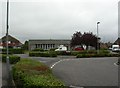
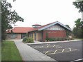
Somerford Community Centre
At the corner of Southey and Amethyst Roads; currently under threat: http://www.bournemouthecho.co.uk/news/districts/christchurch/8180214.Battle_to_save_Christchurch_community_centre/
Image: © Mike Faherty
Taken: 26 Aug 2010
0.02 miles
2
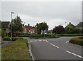
Somerford, roundabout
Small roundabout, complete with yucca trees, on Somerford Estate, at the junction of Southey and Amethyst Roads.
Image: © Mike Faherty
Taken: 26 Aug 2010
0.03 miles
3
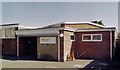
Former Somerford United Reformed Church
Built for the Congregationalists. Now used as a commercial establishment.
Image: © Michael FORD
Taken: Unknown
0.03 miles
4
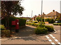
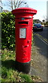
Christchurch: postbox № BH23 46, Southey Road
This Elizabeth II-reign postbox, on the corner of Amethyst Road (along which we are looking) is emptied finally at 5pm on weekdays and at noon on Saturdays.
Image: © Chris Downer
Taken: 9 Aug 2009
0.05 miles
5
High Cross Church
This new church, built in 2004, is an ecumenical partnership between the Church of England and the United Reformed Church. This single building replaces two separate buildings on approximately the same site. The services of the two "churches" are held separately, with their own priests.
Image: © mike smith
Taken: 15 Jul 2007
0.05 miles
6
High Cross Church, Somerford
This Church is shared between the Anglicans and the United Reformed Church.
Image: © Michael FORD
Taken: Unknown
0.05 miles
7
Somerford, High Cross Church
Anglican/URC church on Somerford Estate. The church has two entrances; this is as seen from Scotts Green. http://www.christchurchfellowshipofchurches.org.uk/highcross.html
Image: © Mike Faherty
Taken: 26 Aug 2010
0.07 miles
8
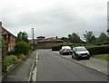
Amethyst Road, Somerford
This is typical of the housing on the Somerford Estate.
Image: © mike smith
Taken: 15 Jul 2007
0.07 miles
9
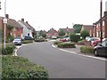
George VI postbox on Newlands Road
See https://www.geograph.org.uk/photo/7318278 for context.
Postbox No. BH23 52.
Image: © JThomas
Taken: 22 Mar 2022
0.11 miles
10
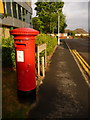
Somerford: postbox № BH23 52, Somerford Road
This George VI-reign postbox is on the corner of Newlands Road, along which we are looking, and is emptied finally at 5:45pm on weekdays and at 1pm on Saturdays.
Image: © Chris Downer
Taken: 14 Jul 2009
0.11 miles