IMAGES TAKEN NEAR TO
Dorset Road, CHRISTCHURCH, BH23 3DJ
Introduction
This page details the photographs taken nearby to Dorset Road, BH23 3DJ by members of the Geograph project.
The Geograph project started in 2005 with the aim of publishing, organising and preserving representative images for every square kilometre of Great Britain, Ireland and the Isle of Man.

There are currently over 7.5m images from over14,400 individuals and you can help contribute to the project by visiting https://www.geograph.org.uk
Image Map (Loading...)


Getting Data...Please wait
Leaflet Map data © OpenStreetMap
Images are licensed for reuse under creativecommons.org/licenses/by-sa/2.0
Notes
- Clicking on the map will re-center to the selected point.
- The higher the marker number, the further away the image location is from the centre of the postcode.
Image Listing (19 Images Found)
Images are licensed for reuse under creativecommons.org/licenses/by-sa/2.0
Image
Details
Distance
1
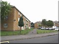
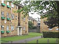
Blocks of Flats at Somerford
This densely populated area includes several blocks of 3-story flats.
Image: © mike smith
Taken: 15 Jul 2007
0.06 miles
2
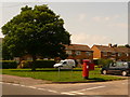
Christchurch: postbox № BH23 78, Charles Road
This Elizabeth II-reign postbox stands on the corner of Charles and Hunt Roads, part of a fairly large council estate. It is emptied finally at 5pm on weekdays and at noon on Saturdays.
Image: © Chris Downer
Taken: 9 Aug 2009
0.06 miles
3
Blocks of Flats at Somerford
There are a dozen or so of these 3-story blocks on the Somerford Estate.
Image: © mike smith
Taken: 15 Jul 2007
0.06 miles
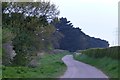
4
Burton, Ambury Lane
Country lane from Staple Cross to Watery Lane.
Image: © Mike Faherty
Taken: 16 Apr 2014
0.08 miles
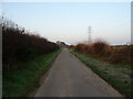
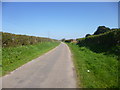
5
Ambury Lane
Here forming part of Route 2 of the National Cycle Network.
Image: © David Lally
Taken: 7 May 2013
0.10 miles
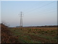
6
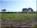
Burton, horse grazing
Between Ambury Lane and Christchurch By-pass, with Somerford housing in the distance.
Image: © Mike Faherty
Taken: 16 Apr 2014
0.15 miles
7
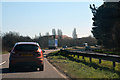
Christchurch : Christchurch Bypass A35
A road heading through Christchurch.
Image: © Lewis Clarke
Taken: 26 Mar 2018
0.16 miles
8
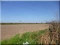
Burton, ploughed field
Between Ambury Lane and railway embankment on the Weymouth to Waterloo line; power lines in the foreground.
Image: © Mike Faherty
Taken: 16 Apr 2014
0.17 miles