IMAGES TAKEN NEAR TO
Hill View Road, FERNDOWN, BH22 9QY
Introduction
This page details the photographs taken nearby to Hill View Road, BH22 9QY by members of the Geograph project.
The Geograph project started in 2005 with the aim of publishing, organising and preserving representative images for every square kilometre of Great Britain, Ireland and the Isle of Man.

There are currently over 7.5m images from over14,400 individuals and you can help contribute to the project by visiting https://www.geograph.org.uk
Image Map
Images are licensed for reuse under creativecommons.org/licenses/by-sa/2.0
Notes
- Clicking on the map will re-center to the selected point.
- The higher the marker number, the further away the image location is from the centre of the postcode.
Image Listing (4 Images Found)
Images are licensed for reuse under creativecommons.org/licenses/by-sa/2.0
Image
Details
Distance
1
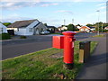
Ferndown: postbox № BH22 120, Coppice Avenue
This postbox is at the eastern end of Coppice Avenue, close to the junction of Ameysford Road. It is emptied finally at 5:15pm on weekdays and at 12:15pm on Saturdays.
Image: © Chris Downer
Taken: 15 Jun 2009
0.12 miles
2
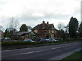
Ferndown, The Pure Drop
Pub on Wimborne Road East. Internally, open-plan on two levels, with oval central bar and eating & drinking areas on three sides; darts. Due to shut for refurbishment soon. Cask ale on offer at my visit: Ringwood Best. For some customer comments, see http://www.beerintheevening.com/pubs/s/59/5934/Pure_Drop/Ferndown
Image: © Mike Faherty
Taken: 17 Jan 2010
0.14 miles
3
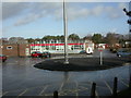
Ferndown Upper School
Off Cherry Grove. http://www.fernup.dorset.sch.uk/
Image: © Mike Faherty
Taken: 17 Jan 2010
0.22 miles