IMAGES TAKEN NEAR TO
Glenmoor Road, FERNDOWN, BH22 8PW
Introduction
This page details the photographs taken nearby to Glenmoor Road, BH22 8PW by members of the Geograph project.
The Geograph project started in 2005 with the aim of publishing, organising and preserving representative images for every square kilometre of Great Britain, Ireland and the Isle of Man.

There are currently over 7.5m images from over14,400 individuals and you can help contribute to the project by visiting https://www.geograph.org.uk
Image Map
Images are licensed for reuse under creativecommons.org/licenses/by-sa/2.0
Notes
- Clicking on the map will re-center to the selected point.
- The higher the marker number, the further away the image location is from the centre of the postcode.
Image Listing (11 Images Found)
Images are licensed for reuse under creativecommons.org/licenses/by-sa/2.0
Image
Details
Distance
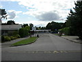
1
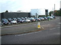
Car Sales, West Parley, Dorset
This Porsche Garage is situated on the A347 next to the residential area of West Parley. The photo is taken at the road junction of New road, Dudsbury Road and Glenmoor Road.
Image: © Stuart Buchan
Taken: 12 Dec 2005
0.10 miles
2
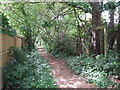
Footpath to New Road, Ferndown
This footpath goes from Golf Links Road to New Road.
Image: © Lorraine and Keith Bowdler
Taken: 23 May 2011
0.14 miles
3
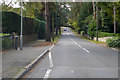
Golf Links Road, Ferndown
A street of large houses among mature trees on the eastern edge of Ferndown.
Image: © David Martin
Taken: 17 Apr 2023
0.15 miles
4
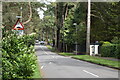
Golf Links Road, Ferndown
A great many humps and chicanes 'traffic calming' in this road.
Image: © Robin Webster
Taken: 3 Nov 2018
0.15 miles
5
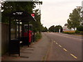
West Parley: postbox № BH22 157 and phone, New Road
This Elizabeth II-reign postbox stands between a bus shelter and a phone box, and is emptied finally at 5:15pm on weekdays and at noon on Saturdays.
Image: © Chris Downer
Taken: 8 Jun 2009
0.19 miles
6
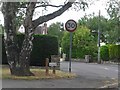
West Parley: old speed limit sign, Mags Barrow
This '30' sign has been here very many years; the pointy three is a giveaway. Even the pillar is original; there is a faint trace of the black and white stripes, most discernible near the bottom of the pole.
The road nameplate is an old Wimborne District Council one too – the council was renamed East Dorset District about 25 years ago – still on its original pebble-dashed posts.
Mags Barrow is a small road, which comes out again a bit further east, named after an ancient burial mound called Mags Barrow, which still stands nearby.
Image: © Chris Downer
Taken: 9 Jun 2009
0.21 miles
7
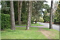
Trees on the verge beside Golf Links Road
Image: © David Martin
Taken: 17 Apr 2023
0.23 miles
8
West Parley: postbox № BH22 185, Fitzpain Road
A modern postbox on this 1960s housing estate; a gap in the housing ahead has been left ahead of us, as a recreational field. The postbox is emptied finally at 5pm on weekdays and at noon on Saturdays.
Image: © Chris Downer
Taken: 15 Jun 2009
0.23 miles
9
Parley First School
Off Glenmoor Road. http://www.parley.dorset.sch.uk/aboutschool/school_history.htm
Image: © Mike Faherty
Taken: 28 Aug 2010
0.23 miles
10
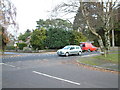
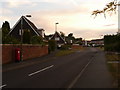
Road Junction, West Parley, Dorset
This road junction is in the centre of the residential area of West Parley.
Image: © Stuart Buchan
Taken: 12 Dec 2005
0.24 miles