IMAGES TAKEN NEAR TO
Mags Barrow, FERNDOWN, BH22 8PD
Introduction
This page details the photographs taken nearby to Mags Barrow, BH22 8PD by members of the Geograph project.
The Geograph project started in 2005 with the aim of publishing, organising and preserving representative images for every square kilometre of Great Britain, Ireland and the Isle of Man.

There are currently over 7.5m images from over14,400 individuals and you can help contribute to the project by visiting https://www.geograph.org.uk
Image Map
Images are licensed for reuse under creativecommons.org/licenses/by-sa/2.0
Notes
- Clicking on the map will re-center to the selected point.
- The higher the marker number, the further away the image location is from the centre of the postcode.
Image Listing (11 Images Found)
Images are licensed for reuse under creativecommons.org/licenses/by-sa/2.0
Image
Details
Distance
1
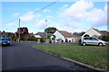
Houses in Mag's Barrow
Mag's Barrow is a long residential road with a large number of bungalows just off and parallel to New Road , West parley
Image: © Nigel Mykura
Taken: 7 Feb 2019
0.03 miles
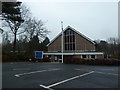
3
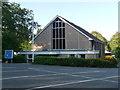
West Parley: parish church of St. Mark
A modern church for the parish, which rapidly expanded in the latter half of the 20th century, at 250 New Road. The small, ancient parish church does still survive, at the end of Church Lane well away from the modern-day centre of the village.
Image: © Chris Downer
Taken: 12 Jun 2014
0.11 miles
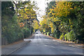
4
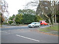
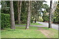
Road Junction, West Parley, Dorset
This road junction is in the centre of the residential area of West Parley.
Image: © Stuart Buchan
Taken: 12 Dec 2005
0.13 miles
5
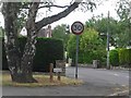
West Parley: old speed limit sign, Mags Barrow
This '30' sign has been here very many years; the pointy three is a giveaway. Even the pillar is original; there is a faint trace of the black and white stripes, most discernible near the bottom of the pole.
The road nameplate is an old Wimborne District Council one too – the council was renamed East Dorset District about 25 years ago – still on its original pebble-dashed posts.
Mags Barrow is a small road, which comes out again a bit further east, named after an ancient burial mound called Mags Barrow, which still stands nearby.
Image: © Chris Downer
Taken: 9 Jun 2009
0.16 miles
6
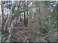
Trees on the verge beside Golf Links Road
Image: © David Martin
Taken: 17 Apr 2023
0.16 miles
7
Ralph's Barrow, West Parley
This tumuli is in a garden in Lone Pine Drive.
Image: © Lorraine and Keith Bowdler
Taken: 1 Mar 2010
0.16 miles
8
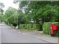
West Parley: postbox № BH22 176, Chine Walk
I'm sure I recall, about 25 years ago, the postbox here being a wall box set into a brick pillar. Either it has been replaced in recent years, or I'm getting it confused with Image a short distance away. But I wonder if that concrete square just to the left of the current box marks its former position.
Anyhow, it is an Elizabeth II-reign box and its advertised final collection times are 5:15pm on weekdays and noon on Saturdays.
Image: © Chris Downer
Taken: 9 Jun 2009
0.17 miles
9
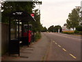
West Parley: postbox № BH22 157 and phone, New Road
This Elizabeth II-reign postbox stands between a bus shelter and a phone box, and is emptied finally at 5:15pm on weekdays and at noon on Saturdays.
Image: © Chris Downer
Taken: 8 Jun 2009
0.18 miles
10
A347 New Road
Heading towards central Bournemouth.
Image: © Robin Webster
Taken: 3 Nov 2018
0.20 miles