IMAGES TAKEN NEAR TO
Barns Road, FERNDOWN, BH22 8AF
Introduction
This page details the photographs taken nearby to Barns Road, BH22 8AF by members of the Geograph project.
The Geograph project started in 2005 with the aim of publishing, organising and preserving representative images for every square kilometre of Great Britain, Ireland and the Isle of Man.

There are currently over 7.5m images from over14,400 individuals and you can help contribute to the project by visiting https://www.geograph.org.uk
Image Map
Images are licensed for reuse under creativecommons.org/licenses/by-sa/2.0
Notes
- Clicking on the map will re-center to the selected point.
- The higher the marker number, the further away the image location is from the centre of the postcode.
Image Listing (4 Images Found)
Images are licensed for reuse under creativecommons.org/licenses/by-sa/2.0
Image
Details
Distance
1
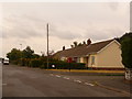
Ferndown: postbox № BH22 191, Barns Road
This little postbox is one of four in the estate accessed off Trickett's Cross which have identical last collection times: 5:15pm on weekdays and 12:30pm on Saturdays.
Image: © Chris Downer
Taken: 8 Jun 2009
0.06 miles
2
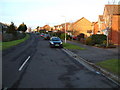
Tricketts Cross, Dorset
This residential area is situated to the north of Parley Common an important herpetological area.
Image: © Stuart Buchan
Taken: 12 Dec 2005
0.12 miles
3
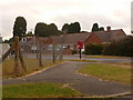
Ferndown: postbox № BH22 194, Corbin Avenue
This little postbox is one of four in the estate accessed off Trickett's Cross which have identical last collection times: 5:15pm on weekdays and 12:30pm on Saturdays.
Image: © Chris Downer
Taken: 8 Jun 2009
0.14 miles
4
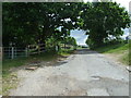
Gate to Palmer's Ford, Trickett's Cross
Image: © Lorraine and Keith Bowdler
Taken: 20 May 2011
0.19 miles