IMAGES TAKEN NEAR TO
Station Road, FERNDOWN, BH22 0HZ
Introduction
This page details the photographs taken nearby to Station Road, BH22 0HZ by members of the Geograph project.
The Geograph project started in 2005 with the aim of publishing, organising and preserving representative images for every square kilometre of Great Britain, Ireland and the Isle of Man.

There are currently over 7.5m images from over14,400 individuals and you can help contribute to the project by visiting https://www.geograph.org.uk
Image Map
Images are licensed for reuse under creativecommons.org/licenses/by-sa/2.0
Notes
- Clicking on the map will re-center to the selected point.
- The higher the marker number, the further away the image location is from the centre of the postcode.
Image Listing (39 Images Found)
Images are licensed for reuse under creativecommons.org/licenses/by-sa/2.0
Image
Details
Distance
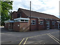
2
West Moors Memorial Hall
On Station Road, with adjacent Social Club. http://www.westmoorsdorset.co.uk/memorialhall.htm
Image: © Mike Faherty
Taken: 2 Jan 2010
0.01 miles
3
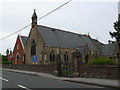
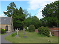
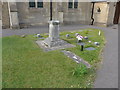
Parish Church West Moors
In 1896 the present church building was built and was blessed and dedicated as Saint Mary the Virgin on 9th December 1897 (but not consecrated) by the then Bishop of Salisbury. In March 2010 work began on the new building on the other side of the church which is the new church hall which replaced the old 1970's structure with its very leaky flat roof. The new hall was opened and dedicated by The Archdeacon of Sherborne, The Venerable Paul Taylor on Saturday 16th October 2010. This far more substantial building provides the parish with much needed modern facilities of kitchen, toilets, storage and a considerably larger hall.
Image: © Nigel Mykura
Taken: 27 Jun 2012
0.02 miles
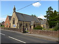
6
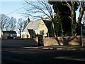
West Moors, parish church
Parish church of St. Mary the Virgin, on Station Road at the junction with The Avenue. http://www.stmaryswestmoors.org.uk/
Image: © Mike Faherty
Taken: 2 Jan 2010
0.04 miles
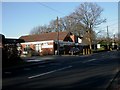
8

NEW
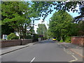
Station Road, West Moors
A speed camera on Station Road, West Moors.
The road name is a clue that West Moors used to have a railway station. Trains no longer serve West Moors, as the station closed to passengers in 1964.
The road is on the route of the B3072. This section is also on the route of the Castleman Trailway and route 256 of the National Cycle Network, which turn off to the left just ahead.
Image: © Malc McDonald
Taken: 9 Mar 2025
0.04 miles
10
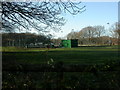
West Moors, football pitches
Off Station Road, behind Image
Image: © Mike Faherty
Taken: 2 Jan 2010
0.07 miles